IMAGES TAKEN NEAR TO
Nottingham Road, MANSFIELD, NG18 4AJ
Introduction
This page details the photographs taken nearby to Nottingham Road, NG18 4AJ by members of the Geograph project.
The Geograph project started in 2005 with the aim of publishing, organising and preserving representative images for every square kilometre of Great Britain, Ireland and the Isle of Man.

There are currently over 7.5m images from over14,400 individuals and you can help contribute to the project by visiting https://www.geograph.org.uk
Image Map
Images are licensed for reuse under creativecommons.org/licenses/by-sa/2.0
Notes
- Clicking on the map will re-center to the selected point.
- The higher the marker number, the further away the image location is from the centre of the postcode.
Image Listing (31 Images Found)
Images are licensed for reuse under creativecommons.org/licenses/by-sa/2.0
Image
Details
Distance
1

Shops and houses, Nottingham Road, Mansfield
Image: © Jonathan Thacker
Taken: 13 Jan 2022
0.01 miles
2
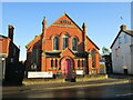
Bethel Methodist Church, Mansfield
Image: © Jonathan Thacker
Taken: 13 Jan 2022
0.05 miles
3
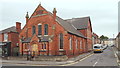
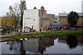
Mansfield, Notts.
Looking eastwards along Gedling Street. Bethel Methodist Church (formerly of the Primitive Methodist persuasion), dating from 1896, is seen here from the opposite side of the Nottingham-Mansfield Road (the A60).
Image: © David Hallam-Jones
Taken: 13 Sep 2013
0.06 miles
4
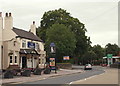
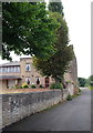
Mansfield, Notts.
The Talbot Inn at the side of Nottingham Road (the A60). The car in the picture is leaving Mansfield and heading towards Nottingham. The Earldom of Shrewsbury, in its second creation, featured many members of the Talbot family. George Talbot, who became the 6th Earl of Shrewsbury in 1590 became owner of nearby Rufford Abbey and his descendants continued to live there until 1938 when the house and land were largely sold off. It may be that this public house and Talbot Street - behind the photographer - have this association?
Image: © David Hallam-Jones
Taken: 14 Sep 2013
0.12 miles
5
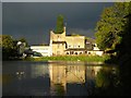
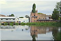
Field Mill Pond
Seen in dramatic evening sunlight across Field Mill Pond, this house dates back to the late 18th century. It was the Master's house of Field Mill. The mill itself, which was demolished in 1925, stood immediately to the left of the house and towered over it. After standing empty for many years, the house was converted to a pub (Early Doors) in the 1990's and is now an Indian Restaurant.
You can see an old photo (pre-1925) showing the house and mill here http://www.old-mansfield.org.uk/tales/newbook.htm
Image: © Antony Dixon
Taken: 14 Oct 2012
0.15 miles
7
Mansfield, Notts.
This is a service road that branches off Nottingham Road and terminates at the rear of a commercial laundry, i.e. its loading and unloading area are situated off-right. Field Mill House, currently an Indian restaurant, was the mill manager's house. The former mill pond lies at the top of the gentle slope ahead. This area is an integral part of the Maun Valley Trail.
Image: © David Hallam-Jones
Taken: 13 Sep 2013
0.16 miles
8
Mansfield, Notts.
On the right, and showing obvious signs of having been adapted for commercial purposes, this brick building was once the Field Mill manager's house. The mill, formerly a corn mill that was later adapted for cotton spinning purposes in 1788, was situated behind the photographer's left shoulder. Having stood empty for a considerable number of years after the mill ceased to function, the manager's house was converted into "The Early Doors" pub, before it took on its present day restaurant function. The buildings on the left are part of a large commercial laundry. The former mill pond is now an angler's paradise and part of the Maun Valley trail.
Image: © David Hallam-Jones
Taken: 13 Sep 2013
0.16 miles
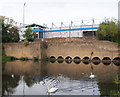
9
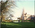
Field Mill Dam, Mansfield, Notts.
A view of Field Mill Dam from Quarry Lane Nature Reserve. Field Mill, a.k.a. Greenhalgh's Mill, was demolished in 1924. It had a waterwheel 40ft in diameter, one of the biggest in England. Ernest “Harwood” Greenhalgh (1849-1922) was an English footballer who played for England as a full back. In 1833, after retiring from playing, Greenhalgh continued to play an important part in the development of English football, helping to found Greenhalgh's F.C. in Mansfield. He was also one-time owner of Field Mill.
Image: © David Hallam-Jones
Taken: 19 Nov 2017
0.18 miles
10
Mansfield, Notts.
Only a section of the mill pond wall and water intake conduits remain of a former mill that existed here. Field Mill was originally a corn mill that was later acquired by a Nottingham hosiery company for use as a cotton mill. Following its purchase the mill was adapted and upgraded and the mill pond increased in size. Thereafter spinning was conducted here between 1788-1812. Although the buildings were used for other purposes after its cotton spinning role ceased, the premises were eventually purchased by the local Council and finally demolished in the 1920s. The former mill pond, formed by the dammed River Maun, is now an angler's paradise and part of the Maun Valley trail. Mansfield Town Football Club's Field Mill ground providing a backdrop. Quarry Lane runs between the lower and the higher stone walls.
Image: © David Hallam-Jones
Taken: 13 Sep 2013
0.18 miles