IMAGES TAKEN NEAR TO
Portland Street, MANSFIELD, NG18 1HE
Introduction
This page details the photographs taken nearby to Portland Street, NG18 1HE by members of the Geograph project.
The Geograph project started in 2005 with the aim of publishing, organising and preserving representative images for every square kilometre of Great Britain, Ireland and the Isle of Man.

There are currently over 7.5m images from over14,400 individuals and you can help contribute to the project by visiting https://www.geograph.org.uk
Image Map
Images are licensed for reuse under creativecommons.org/licenses/by-sa/2.0
Notes
- Clicking on the map will re-center to the selected point.
- The higher the marker number, the further away the image location is from the centre of the postcode.
Image Listing (93 Images Found)
Images are licensed for reuse under creativecommons.org/licenses/by-sa/2.0
Image
Details
Distance
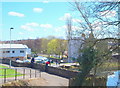
1
Mansfield, Notts (Portland Street)
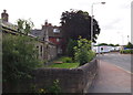
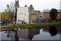
A view of Portland Street (formerly Bull’s Head Lane) looking towards its junction with Nottingham Road. On the left are the "additional six" almshouses built in 1844 and funded by the Elizabeth Heath Charity. Although this row of cottages "for ancient ladies" was in use until the Winter of 2011/12 they are now empty and boarded up. The original single-bedroomed almshouses – twelve in number – are situated on Nottingham Road and are still inhabited. Elizabeth Heath (1617-93), a Mansfield resident and a Quaker, endowed these almshouses for women born in Mansfield or having lived in Mansfield for a substantial part of their lives and with limited assets - criteria that remain in use today. The allocation of residents i.e. "six Quakers and six church members of the established church" presumably demonstrated a wish to avoid clashing with the Anglican authorities given that Quakers were frequently shunned by most other authorities at this time?
Image: © David Hallam-Jones
Taken: 15 Jul 2012
0.01 miles
2
Mansfield, Notts.
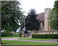
St Mark's Church is seen here from inside to one of the Nottingham Road (A60) access points into and out of Titchfield Park. The building - in stone - by Temple Moore, was opened in 1897. It was built on the site of a temporary iron building that had succeeded the 'Navvy Mission' (for workers employed in building the railway line to Worksop), and which had served as the parish church of St Mark from 1889, when the parish was created.
The building consists of nave, side chapel and a small tower at the south east corner containing one bell by Mears & Stainbank, cast in 1892. The exterior is almost conventional neo-Perpendicular, plain but dignified.
Image: © David Hallam-Jones
Taken: 13 Sep 2013
0.07 miles
3
Mansfield, Notts.
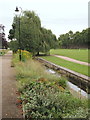
The 'busy' River Maun making its way through Titchfield Park, its two sides being linked by several bridges. This fairly extensive plot of land has been a recreational area since 1880. It was formerly known as Nottingham Road Pleasure Grounds or The Water Meadows. It was renamed Titchfield Park in 1914, to mark the coming of age of the Duke of Portland's son, Marquis of Titchfield. This green corridor forms part of the Maun Valley Trail. Nottingham Road (the A60) semi-encompasses the park, behind and to the left of this shot.
Image: © David Hallam-Jones
Taken: 13 Sep 2013
0.09 miles
4
Mansfield, Notts.
This is a service road that branches off Nottingham Road and terminates at the rear of a commercial laundry, i.e. its loading and unloading area are situated off-right. Field Mill House, currently an Indian restaurant, was the mill manager's house. The former mill pond lies at the top of the gentle slope ahead. This area is an integral part of the Maun Valley Trail.
Image: © David Hallam-Jones
Taken: 13 Sep 2013
0.09 miles
6
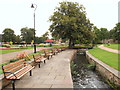
Mansfield, Notts.
One of several bridges that crosses the ‘busy’ River Maun in Titchfield Park. In 1914 it was renamed, from “Nottingham Road Pleasure Grounds” (a.k.a. The Water Meadows), to mark the coming of age of the Duke of Portland's son, the Marquis of Titchfield. Opened in 1881, today the park offers ornamental gardens, playground areas, a multi-purpose games area, a pavilion, a performance area, pétanque pistes and a meadow area for informal recreation. The riverside walk forms part of the Maun Valley Trail.
Image: © David Hallam-Jones
Taken: 13 Sep 2013
0.10 miles
7
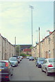
Mansfield, Notts.
A corner of the Field Mill football ground seen from elevated end of Lord Street, a cul-de-sac.
Image: © David Hallam-Jones
Taken: 13 Sep 2013
0.10 miles
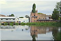
8
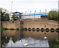
Mansfield, Notts.
Only a section of the mill pond wall and water intake conduits remain of a former mill that existed here. Field Mill was originally a corn mill that was later acquired by a Nottingham hosiery company for use as a cotton mill. Following its purchase the mill was adapted and upgraded and the mill pond increased in size. Thereafter spinning was conducted here between 1788-1812. Although the buildings were used for other purposes after its cotton spinning role ceased, the premises were eventually purchased by the local Council and finally demolished in the 1920s. The former mill pond, formed by the dammed River Maun, is now an angler's paradise and part of the Maun Valley trail. Mansfield Town Football Club's Field Mill ground providing a backdrop. Quarry Lane runs between the lower and the higher stone walls.
Image: © David Hallam-Jones
Taken: 13 Sep 2013
0.10 miles
9
Portland Road Vicinity, Mansfield, Notts.
Pedestrians and cyclists use this descending path (with its railings) to get from Quarry Lane to Nottingham Road in the distance. Field Mill, where these observers are standing, was originally a corn mill but it was later acquired by a Nottingham hosiery company as a cotton mill and spinning was carried out between 1788-1812. Although the buildings were used for other purposes the premises after cotton spinning was discontinued, the premises were eventually purchased by the local Council and finally demolished in the 1920s. The buildings on the left are part of a large commercial laundry. The former mill pond, formed by the dammed River Maun, is now an angler's paradise and part of the Maun Valley trail.
Image: © David Hallam-Jones
Taken: 17 Apr 2016
0.10 miles
10
Mansfield, Notts.
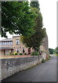
On the right, and showing obvious signs of having been adapted for commercial purposes, this brick building was once the Field Mill manager's house. The mill, formerly a corn mill that was later adapted for cotton spinning purposes in 1788, was situated behind the photographer's left shoulder. Having stood empty for a considerable number of years after the mill ceased to function, the manager's house was converted into "The Early Doors" pub, before it took on its present day restaurant function. The buildings on the left are part of a large commercial laundry. The former mill pond is now an angler's paradise and part of the Maun Valley trail.
Image: © David Hallam-Jones
Taken: 13 Sep 2013
0.10 miles