IMAGES TAKEN NEAR TO
Peartree Lane, SUTTON-IN-ASHFIELD, NG17 3LE
Introduction
This page details the photographs taken nearby to Peartree Lane, NG17 3LE by members of the Geograph project.
The Geograph project started in 2005 with the aim of publishing, organising and preserving representative images for every square kilometre of Great Britain, Ireland and the Isle of Man.

There are currently over 7.5m images from over14,400 individuals and you can help contribute to the project by visiting https://www.geograph.org.uk
Image Map
Images are licensed for reuse under creativecommons.org/licenses/by-sa/2.0
Notes
- Clicking on the map will re-center to the selected point.
- The higher the marker number, the further away the image location is from the centre of the postcode.
Image Listing (29 Images Found)
Images are licensed for reuse under creativecommons.org/licenses/by-sa/2.0
Image
Details
Distance
1
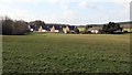
New dwellings
This view of new dwellings (and one much older) on Image was taken just a few metres west of a bridge that carries Image over the Teversal Trail.
An OS map surveyed in 1875 and published in 1877 http://maps.nls.uk/view/137933983 shows a dwelling on the site of the older property in the photograph. This map also records Peartree Lane as then being known as Marker Lane.
Image: © Alan Walker
Taken: 15 Feb 2018
0.01 miles
2
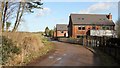
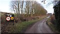
Peartree Lane
This northerly facing photograph is of Peartree Lane shows some relatively new-build properties on what was once the site of a 'works'. The 'works' may have been the property of AR Parker Transport Limited, which was dissolved on 2008-02-19 https://www.companieslist.co.uk/05101882-ar-parker-transport-limited .
For another photograph of the lane taken some 300m ahead, click here:- Image
For another photograph of the lane taken some 200m behind the viewpoint, click here:- Image
Image: © Alan Walker
Taken: 15 Feb 2018
0.02 miles
3
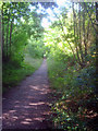
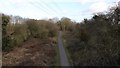
Teversal to Pleasley railway - 2
Looking southwards from under the Peartree Lane bridge. The old trackbed has now been converted to a cycleway and part of it is also a nature reserve, which has rare plants in the cutting through limestone rock.
Image: © Trevor Rickard
Taken: 11 Sep 2009
0.08 miles
4
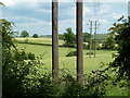
Fields and line of power poles
View from the former railway line north of Teversal.
Image: © Andrew Hill
Taken: 9 Jun 2011
0.12 miles
5
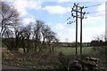
Power lines
This easterly facing photograph, taken from the Teversal Trail, shows power lines at a point where they change direction as they make their way, behind the viewpoint, toward Fackley. Ahead the lines pass Dawgates Farm on their way to the outskirts of Mansfield.
When the photograph was taken, shrubbery and undergrowth below the route of the cables had fairly recently been cleared.
See also this photograph by Andrew Hill:- Image
Image: © Alan Walker
Taken: 15 Feb 2018
0.12 miles
6
Peartree Lane
This northerly facing photograph is of Peartree Lane and is looking toward some relatively new-build properties on what was once the site of a 'works'. The 'works' may have been the property of AR Parker Transport Limited, which was dissolved on 2008-02-19 https://www.companieslist.co.uk/05101882-ar-parker-transport-limited .
For another photograph of the lane taken some 200m ahead, click here:- Image
For another photograph of the lane taken some 100m behind the viewpoint, click here:- Image
Image: © Alan Walker
Taken: 15 Feb 2018
0.13 miles
7
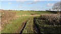
Peartree Lane
This northerly facing photograph is of the bridleway, Peartree Lane. It was taken at a point where, according to the OS map a public right of way leaves the lane and heads off across the field toward Norwood. This is clearly no longer the case and to reach Norwood the walker must follow the lane round to the right and then branch onto a path along the hedge-line on the far side of the field.
For another photograph of the lane taken some 215m ahead, click here:- Image
For another photograph of the lane taken some 300m behind the viewpoint, click here:- Image
Image: © Alan Walker
Taken: 15 Feb 2018
0.15 miles
8
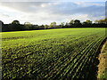
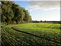
Autumn sown crop alongside Peartree Lane
Image: © Jonathan Thacker
Taken: 25 Oct 2021
0.15 miles
9
The Teversal Trail
This northerly facing photograph is of the Teversal Trail and was taken from a bridge that carries Image over the trail.
For a photograph of the power lines taken from the trail below, click here:- Image
See also this photograph by Andrew Hill:- Image
Image: © Alan Walker
Taken: 15 Feb 2018
0.15 miles
10
Autumn sown crop near Hucklecroft Cottage
Image: © Jonathan Thacker
Taken: 25 Oct 2021
0.16 miles