IMAGES TAKEN NEAR TO
Burradon Road, CRAMLINGTON, NE23 7ND
Introduction
This page details the photographs taken nearby to Burradon Road, NE23 7ND by members of the Geograph project.
The Geograph project started in 2005 with the aim of publishing, organising and preserving representative images for every square kilometre of Great Britain, Ireland and the Isle of Man.

There are currently over 7.5m images from over14,400 individuals and you can help contribute to the project by visiting https://www.geograph.org.uk
Image Map (Loading...)


Getting Data...Please wait
Leaflet Map data © OpenStreetMap
Images are licensed for reuse under creativecommons.org/licenses/by-sa/2.0
Notes
- Clicking on the map will re-center to the selected point.
- The higher the marker number, the further away the image location is from the centre of the postcode.
Image Listing (18 Images Found)
Images are licensed for reuse under creativecommons.org/licenses/by-sa/2.0
Image
Details
Distance
1
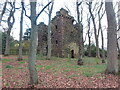
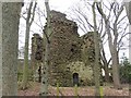
Burradon Tower, Burradon
Burradon Tower is a ruined Pele Tower (defensive tower), built during times of hostilities with Scotland. The Tower is a Grade II listed building and a Scheduled Ancient Monument. The Tower was the focal point of the medieval village of Burradon. The Tower was at one time incorporated into an adjoining farm building. Now it stands alone, enclosed by a stone wall and surrounded by tall trees at Burradon Farm. For a selection of detailed free to download walking routes in the area visit www.northtynesidewalks.co.uk
Image: © Geoff Holland
Taken: 17 Nov 2020
0.02 miles
2
Burradon Tower
Burradon Tower was originally of three storeys and is thought to have been constructed in the 16th century. It is a scheduled ancient monument. Defensible tower houses of this type are characteristic of the border region between England and Scotland.
Image: © Oliver Dixon
Taken: 23 Feb 2012
0.02 miles
3
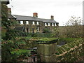
Row of Cottages, Burradon House
These are the same cottages as shown at https://www.geograph.org.uk/photo/6678634 although seen from a different angle. There were cottages here prior to the publication of the first Ordnance Survey Six-Inch map of the area in 1866. For a selection of detailed free to download walking routes in the area visit www.northtynesidewalks.co.uk
Image: © Geoff Holland
Taken: 17 Nov 2020
0.03 miles
4
Row of Cottages, Burradon House
There were cottages here prior to the publication of the first Ordnance Survey Six-Inch map of the area in 1866. For a selection of detailed free to download walking routes in the area visit www.northtynesidewalks.co.uk
Image: © Geoff Holland
Taken: 17 Nov 2020
0.03 miles
5
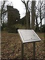
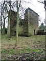
Burradon Tower and information panel
The ruins of Burradon Tower sit within a small wooded area adjacent to the farm and buildings of Burradon House. An interpretation panel gives a brief history of the tower, a Scheduled Monument (link: https://historicengland.org.uk/listing/the-list/list-entry/1018644).
Image: © Graham Robson
Taken: 13 Jan 2018
0.03 miles
6
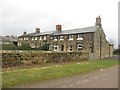
Cottages at Burradon House
A row of two storey sturdily built stone cottages at Burradon House.
Image: © Graham Robson
Taken: 13 Jan 2018
0.03 miles
7
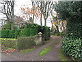
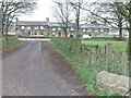
Entrance to Burradon House
When the first Ordnance Survey Six-Inch map of the area was published in 1864 this house did not exist although by the time the second edition appeared in 1898 it had been built. At that time, the house was clearly named as Burradon House whilst, on the current Ordnance Survey map, the house and the small settlement surrounding it appears to be known collectively as Burradon House. For a selection of detailed free to download walking routes in the area visit www.northtynesidewalks.co.uk
Image: © Geoff Holland
Taken: 17 Nov 2020
0.03 miles
8
Burradon Tower
The remains of an old fortified house in a copse adjacent to the farm steading at Burradon House. The ruins are a Scheduled Monument. Link to Historic England listing page: https://historicengland.org.uk/listing/the-list/list-entry/1018644
Image: © Graham Robson
Taken: 13 Jan 2018
0.04 miles
9
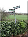
Sign near Burradon Farm
This multi-directional sign has seen better days although it is still just about readable. For a selection of detailed free to download walking routes in the area visit www.northtynesidewalks.co.uk
Image: © Geoff Holland
Taken: 17 Nov 2020
0.05 miles
10
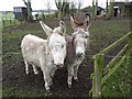
A pair of donkeys
In a paddock opposite Burradon Tower.
Image: © Oliver Dixon
Taken: 23 Feb 2012
0.05 miles