IMAGES TAKEN NEAR TO
Surrey Close, LONDON, N3 3EF
Introduction
This page details the photographs taken nearby to Surrey Close, N3 3EF by members of the Geograph project.
The Geograph project started in 2005 with the aim of publishing, organising and preserving representative images for every square kilometre of Great Britain, Ireland and the Isle of Man.

There are currently over 7.5m images from over14,400 individuals and you can help contribute to the project by visiting https://www.geograph.org.uk
Image Map
Images are licensed for reuse under creativecommons.org/licenses/by-sa/2.0
Notes
- Clicking on the map will re-center to the selected point.
- The higher the marker number, the further away the image location is from the centre of the postcode.
Image Listing (74 Images Found)
Images are licensed for reuse under creativecommons.org/licenses/by-sa/2.0
Image
Details
Distance
1
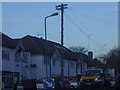
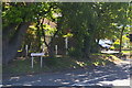
Old type telegraph pole Broughton Avenue
There are only a handful of these left in London, most disappeared soon after the 60s.
Image: © David Howard
Taken: 27 Nov 2009
0.05 miles
2
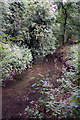
Dollis Brook
The brook meandering beside the footpath. Stands of wild flowers overhang, including Nettles, Cow Parsley and Himalayan Balsam.
Image: © Martin Addison
Taken: 29 Jun 2008
0.06 miles
3
Flats on Broughton Avenue from Windsor open space
Image: © David Howard
Taken: 17 Nov 2011
0.07 miles
4
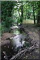
Dollis Brook
A bit more constricted here, but with a clear flow as a result, the brook cuts its way through gravel - these gravel beds around the Finchley area are believed to be remnants of glacier deposits from the last ice age.
Image: © Martin Addison
Taken: 29 Jun 2008
0.08 miles
5
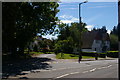
Junction of Crooked Usage with Hendon Lane
One of my favourite London road names.
Image: © Christopher Hilton
Taken: 22 May 2017
0.09 miles
6
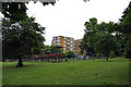
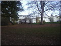
C'mon Daddy
Children rush to the play area at the west end of Wickliffe Avenue. Dad just wonders what he got himself into...
Image: © Martin Addison
Taken: 29 Jun 2008
0.09 miles
7
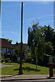
Stink-pipe at junction of Crooked Usage with Hendon Lane
Image: © Christopher Hilton
Taken: 22 May 2017
0.09 miles
8

Bin on legs, Windsor Open Space
It's never walked from this spot.
Image: © David Howard
Taken: 31 May 2020
0.09 miles
9
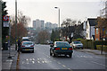
Hendon Lane
Seen at the bus stop for Crooked Usage. Beyond, the road becomes Finchley Lane as it climbs from the Dollis Valley up to Hendon. The tower block on the left of the group in the centre is located behind Sentinel Square on the Belle Vue estate. The next one is on Sentinel Square whilst the right hand pair are on New Brent Street.
Image: © Martin Addison
Taken: 14 Dec 2008
0.10 miles
10
Junction of Crooked Usage with Hendon Lane
Image: © Christopher Hilton
Taken: 22 May 2017
0.10 miles