IMAGES TAKEN NEAR TO
Cornwall Avenue, LONDON, N3 1LH
Introduction
This page details the photographs taken nearby to Cornwall Avenue, N3 1LH by members of the Geograph project.
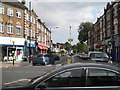
The Geograph project started in 2005 with the aim of publishing, organising and preserving representative images for every square kilometre of Great Britain, Ireland and the Isle of Man.

There are currently over 7.5m images from over14,400 individuals and you can help contribute to the project by visiting https://www.geograph.org.uk
Image Map
Images are licensed for reuse under creativecommons.org/licenses/by-sa/2.0
Notes
- Clicking on the map will re-center to the selected point.
- The higher the marker number, the further away the image location is from the centre of the postcode.
Image Listing (184 Images Found)
Images are licensed for reuse under creativecommons.org/licenses/by-sa/2.0
Image
Details
Distance
1
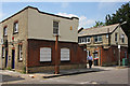
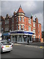
Cornwall Works
A small factory on Cornwall Avenue. I don't know what was made here, but it has now become offices.
Image: © Martin Addison
Taken: 24 Jul 2008
0.02 miles
2
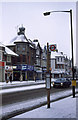
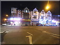
Snow in Finchley Central
A car passes gingerly along Ballards Lane after overnight snow. The end shop in the parade opposite retains its original rooftop decoration. These 'howdahs', for want of a better word, were later removed for safety reasons as current views of Ballards Lane show - the shop at the other end of the parade has already lost its one.
Image: © Martin Addison
Taken: Unknown
0.05 miles
3
Lovers Walk N3
At the junction with Ballards Lane
Image: © Robin Sones
Taken: 21 Sep 2010
0.05 miles
4

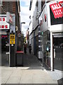
Ballards Lane
Effectively the 'high street' of Finchley Central or Church End as it is known to the locals. A 460 bus passes the junction with Long Lane and Cornwall Avenue. The white office block in the distance is Central House. The corner shops of the closest block used to have an ornamental 'howdah' on top of the conical roof but these were removed some years ago for safety reasons. The evergreen plants and Silver Birch in the foreground are growing in a raised planting area.
Image: © Martin Addison
Taken: 7 Jan 2010
0.06 miles
6
Long Lane N3
At the junction with Ballards Lane
Image: © Robin Sones
Taken: 21 Sep 2010
0.06 miles
7
Ballards Lane at the junction of Long Lane
Image: © David Howard
Taken: 16 Sep 2016
0.06 miles
8
Reeds Rains, Ballards Lane N3
At the junction with Claverley Grove
Image: © Robin Sones
Taken: 21 Sep 2010
0.07 miles
9
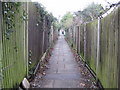
Finchley: Lovers' Walk
A glance at old Victorian large scale Ordnance Survey maps shows that a public right of way between Ballard's Lane and Nether Street, and called Lovers' Walk, existed through here long before the railway, the houses and Wentworth Avenue were ever built. It still offers a link between the fleshpots of Ballard's Lane and the houses to the west, such attractions evidently proving too much for one Saturday night reveller, whose regurgitated chicken tikka masala presented an obstruction to shipping on the Sunday morning, fortunately for those of a fragile nature reading this, some way in the distance ahead.
Image: © Nigel Cox
Taken: 20 Feb 2011
0.08 miles
