IMAGES TAKEN NEAR TO
Ballards Lane, LONDON, N3 1LB
Introduction
This page details the photographs taken nearby to Ballards Lane, N3 1LB by members of the Geograph project.
The Geograph project started in 2005 with the aim of publishing, organising and preserving representative images for every square kilometre of Great Britain, Ireland and the Isle of Man.

There are currently over 7.5m images from over14,400 individuals and you can help contribute to the project by visiting https://www.geograph.org.uk
Image Map
Images are licensed for reuse under creativecommons.org/licenses/by-sa/2.0
Notes
- Clicking on the map will re-center to the selected point.
- The higher the marker number, the further away the image location is from the centre of the postcode.
Image Listing (88 Images Found)
Images are licensed for reuse under creativecommons.org/licenses/by-sa/2.0
Image
Details
Distance
1
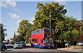
Ballards Lane
A view of the A598 at the junction with Granville Road (on the left). The spire of Finchley Methodist Church is visible in the distances along with the shops that form the north-eastern end of Church End.
TPL461 can be seen on the 460 route, to North Finchley, nearing the end of its run from Willesden.
Image: © Martin Addison
Taken: 5 Sep 2009
0.03 miles
2
Granville Road, Finchley
Looking towards Ballards Lane
Image: © David Howard
Taken: 23 Mar 2022
0.04 miles
3
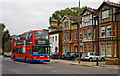
Ballards Lane
TPL239 on the 460 passes the junction with Granville Road with a service for Willesden. Compare this 2010 view with Image taken in 1976. Gardens have been replaced by off-road parking. The lamp post has been replaced by a new one and the old trolleybus pole which carried the signs for Finchley Memorial Hospital and Finchley Reform Synagogue has been removed. The sign for the synagogue is now located at the junction with Montrose Crescent - behind the bus. The house on the right of the photo has become the local Conservative Party office - note the sticker in the window - (I don't think it was in 1976) And, of course, the bus is a Plaxton bodied Trident rather than an AEC Routemaster.
Image: © Martin Addison
Taken: 13 Oct 2010
0.04 miles
4
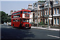
Ballards Lane
RM1295 on the 26 passes the junction with Granville Road with a service for Golders Green. Please see Image for the same location in 2010.
Image: © Martin Addison
Taken: Unknown
0.06 miles
5
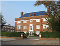
Finchley Court N3
One of two blocks of apartments at the road entrances to the Finchley Court estate. Whilst the other blocks (visible on the left) have flat roofs, these sport beautiful blue pantiles. The main part of the estate is concealed from Ballards Lane by a tall privet hedge.
Image: © Martin Addison
Taken: 16 Oct 2006
0.06 miles
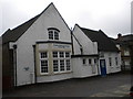
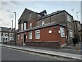
7
Wesleyan Chapel, Ballards Lane N3
At the junction with Essex Park
Image: © Robin Sones
Taken: 21 Sep 2010
0.10 miles
8
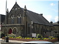
Finchley Methodist Church
Located on Ballards Lane by the junction with Essex Park. The original chapel dates to 1879 when it opened as Wentworth Park Wesleyan chapel. It was designed by Charles Bell. The current church on the left is a much more recent building. Further historical details to be added after more research.
Image: © Martin Addison
Taken: 5 Sep 2009
0.11 miles
9
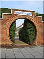
Finchley Court N3
Unusual circular footway entrance to this private housing estate. The estate, on the northwest side of Ballards Lane, is concealed behind a tall privet hedge. two of the apartment blocks are visible through the arch.
Image: © Martin Addison
Taken: 16 Oct 2006
0.11 miles
10
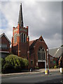
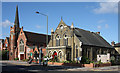
Finchley Methodist Church, Ballards Lane N3
Image: © Robin Sones
Taken: 21 Sep 2010
0.12 miles