IMAGES TAKEN NEAR TO
Prospect Ring, LONDON, N2 8BS
Introduction
This page details the photographs taken nearby to Prospect Ring, N2 8BS by members of the Geograph project.
The Geograph project started in 2005 with the aim of publishing, organising and preserving representative images for every square kilometre of Great Britain, Ireland and the Isle of Man.

There are currently over 7.5m images from over14,400 individuals and you can help contribute to the project by visiting https://www.geograph.org.uk
Image Map
Images are licensed for reuse under creativecommons.org/licenses/by-sa/2.0
Notes
- Clicking on the map will re-center to the selected point.
- The higher the marker number, the further away the image location is from the centre of the postcode.
Image Listing (294 Images Found)
Images are licensed for reuse under creativecommons.org/licenses/by-sa/2.0
Image
Details
Distance
1
Flats on Prospect Place from Stanley Road
Image: © David Howard
Taken: 20 Jun 2014
0.01 miles
2
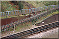
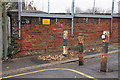
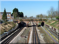
Northern Line Retaining Walls
Walls beside the northbound track in the cutting outside East Finchley Station. The one on the right of the photo is W967 and appears to pre-date the one behind the cables on the left which carries the number W1005.
Image: © Martin Addison
Taken: 26 Nov 2008
0.01 miles
3
Prospect Place
Looking along Prospect Place towards East End Road. The bridge over the Northern Line has long since been closed to road traffic. The houses on the right are in Oakview Gardens. The two thin poles visible at the opposite end of the bridge are eruv markers. An eruv is a contiguous boundary denoted by string or natural markers (such as in this case, the Northern Line) that enables Orthodox Jews to carry items or push baby strollers within its borders during the Sabbath. The string between the poles is too thin to show in the photo.
Image: © Martin Addison
Taken: 21 Sep 2006
0.03 miles
4
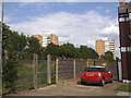
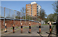
Prospect Place
Looking towards Propect Ring and the bridge over the Northern Line, long since closed to road traffic. The tower block is one of two on Prospect Ring.
Image: © Martin Addison
Taken: 21 Aug 2008
0.03 miles
5
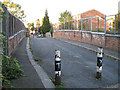
Prospect Place
The bridge over the Northern Line, HB28 - number on the parapet on the left - is blocked by bollards at both ends to prevent vehicles from accessing the bridge. It is somewhat amusing therefore to find that the yellow sign asks for collisions of vehicles with the bridge to be reported to the line controller!
Image: © Martin Addison
Taken: 26 Nov 2008
0.03 miles
6
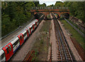
The Northern Line
Looking towards the bridge carrying Prospect Place over the railway to Prospect Ring, from East End Road. The train is bound for High Barnet. Discarded rails litter the areas beside the tracks.
Image: © Martin Addison
Taken: 1 Oct 2008
0.03 miles
7
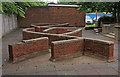
What Is It?
I'm not sure whether this was intended as a children's play area in the 1960's or as a sculpture in brick. It probably works better as the latter, especially as there is a proper playground around the corner by Park Road. Behind are garages for the residents of Propect Ring.
Image: © Martin Addison
Taken: 21 Aug 2008
0.03 miles
8
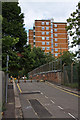
Prospect Place
This narrow road was built circa 1825 to connect East Finchley's market to East End Road. Today it is closed to motor traffic and the market has long since gone. The old centre of East Finchley, which occupied the land around Market Place, Park Road and Chapel Court, was badly damaged by bombing on 15/16 November 1940 and the area was subsequently rebuilt with a mixture of houses and tower blocks. Prospect Place, on the other side of this bridge became Prospect Ring with its associated tower blocks.
Image: © Martin Addison
Taken: 10 Apr 2011
0.04 miles
9
Bridge over Northern Line
Prospect Place crosses, but the bridge is bollarded off to vehicles.
Image: © Robin Webster
Taken: 19 Mar 2011
0.04 miles
10
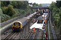
Weekend Line and Station Closures
That's the title of the email notifications sent out every Thursday by Transport for London to advise of planned engineering works. October 5th/6th and 12th/13th would see the High Barnet Branch of the Northern Line closed two weekends in a row for track replacement at Finchley Central and East Finchley. An extensive network of rail replacement buses was provided.
Battery locomotive L52 stands on the southbound tracks as old ballast is replaced by new on the northbound line. The closest excavator is unloading fresh ballast from the wagons which is distributed along the track bed by the dumpster in the foreground. The second excavator is loading the discarded old ballast into wagons that have already been unloaded. The bridge in the distance carries Prospect Place over the line.
Image: © Martin Addison
Taken: 12 Oct 2013
0.04 miles