IMAGES TAKEN NEAR TO
Watermill Lane, LONDON, N18 1FE
Introduction
This page details the photographs taken nearby to Watermill Lane, N18 1FE by members of the Geograph project.
The Geograph project started in 2005 with the aim of publishing, organising and preserving representative images for every square kilometre of Great Britain, Ireland and the Isle of Man.

There are currently over 7.5m images from over14,400 individuals and you can help contribute to the project by visiting https://www.geograph.org.uk
Image Map
Images are licensed for reuse under creativecommons.org/licenses/by-sa/2.0
Notes
- Clicking on the map will re-center to the selected point.
- The higher the marker number, the further away the image location is from the centre of the postcode.
Image Listing (47 Images Found)
Images are licensed for reuse under creativecommons.org/licenses/by-sa/2.0
Image
Details
Distance
1
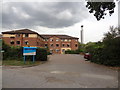
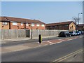
Stamford Nursing Centre
Long and short term care home on the ever changing Watermill Lane Estate, London N18.
Image: © Tony Peacock
Taken: 23 Aug 2012
0.05 miles
2
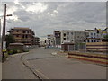
Open Plan Estate lost to New Flats at Watermill Lane
The open plan estate that is still on Google has gone in favour of this new estate.
Image: © Tony Peacock
Taken: 23 Aug 2012
0.06 miles
3

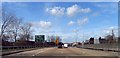
Sterling Way, Edmonton in 1980s
I think this was around 1989 but may have been earlier. North Middlesex Hospital can be seen along the right hand side of the road.
Image: © David Howard
Taken: Unknown
0.07 miles
5
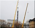
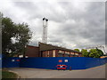
Finally - The last stack
The metal stacks are removed and the rubble will soon be cleared ready for the start of the new build. It is claimed that 81 affordable dwellings will take up the empty space near the railway, the A406 and the North Middlesex Hospital (which is visible in the background).
Image: © Tony Peacock
Taken: 20 Mar 2013
0.09 miles
6
New houses turning their backs to Wilbury Way
The housing development in Wigston Close has created a canyon of back garden fences along the main road.
Image: © Christine Johnstone
Taken: 23 Mar 2012
0.11 miles
7
The Laundry is no more, soon to be demolished
Sinclair's Laundries is situated on valuable land. I wonder what will be built here?
Image: © Tony Peacock
Taken: 23 Aug 2012
0.12 miles
8
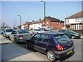
Wilbury Way, N18
A block of houses on the north side of the road.
Image: © Christine Johnstone
Taken: 23 Mar 2012
0.12 miles
9
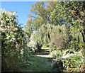
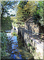
Pymme's Book Trail near the North Circular
Two very different routeways separated by a few allotments.
The Pymme's Brook Trail follows the course of the brook from its source near Cockfosters down to the River Lea. This short bit is possibly its most rustic section.
Image: © Des Blenkinsopp
Taken: 9 Oct 2018
0.13 miles
10
Pymme's Brook Trail by the Brook
The Pymme's Brook Trail follows the course of the brook from its source near Cockfosters down to the River Lea. Due to the nature of urban watercourses it isn't always possible to be this near to the stream, but the route through this square manages to stay closer than usual.
Image: © Des Blenkinsopp
Taken: 9 Oct 2018
0.14 miles