IMAGES TAKEN NEAR TO
Burma Road, LONDON, N16 9BH
Introduction
This page details the photographs taken nearby to Burma Road, N16 9BH by members of the Geograph project.
The Geograph project started in 2005 with the aim of publishing, organising and preserving representative images for every square kilometre of Great Britain, Ireland and the Isle of Man.

There are currently over 7.5m images from over14,400 individuals and you can help contribute to the project by visiting https://www.geograph.org.uk
Image Map
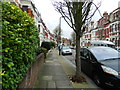
Images are licensed for reuse under creativecommons.org/licenses/by-sa/2.0
Notes
- Clicking on the map will re-center to the selected point.
- The higher the marker number, the further away the image location is from the centre of the postcode.
Image Listing (127 Images Found)
Images are licensed for reuse under creativecommons.org/licenses/by-sa/2.0
Image
Details
Distance
1
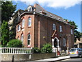
42, Clissold Crescent, N16
Image: © Mike Quinn
Taken: 26 Jun 2008
0.04 miles
2
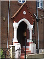
The answer to life, the universe and everything
The porch of Image
Image: © Mike Quinn
Taken: 26 Jun 2008
0.04 miles
3
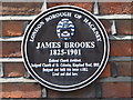
Plaque on 42, Clissold Crescent, N16
Image: © Mike Quinn
Taken: 26 Jun 2008
0.04 miles
4
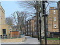
Aden Terrace, London N16
A view from the south-western entrance to Aden Terrace from Green Lanes. The council estate on the right took the place of sixteen Georgian style houses which over-looked the New River until c1953. The Council flats shown, erected in 1956 following demolition of the Georgian style houses, over-look allotments.
Image: © Chris Sitton
Taken: 17 Jun 2007
0.04 miles
5
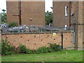
Aden Terrace - Burma Mews, London N16
A view of some not-so-elegant security measures mounted on council estate pram sheds located near Burma Mews. The sheds were formerly the site of 16 Aden Terrace.
Image: © Chris Sitton
Taken: 17 Jun 2007
0.04 miles
6
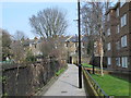
Aden Terrace, London N16
A view north towards Clissold Park and Stoke Newington Church Street from Aden Terrace, which is a short section of the New River Path.
Image: © Chris Sitton
Taken: 17 Jun 2007
0.07 miles
7
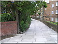
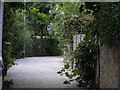
Path between Green Lanes and Clissold Crescent, N16 (2)
The path marks the former course of the New River http://en.wikipedia.org/wiki/New_River_(England).
Image: © Mike Quinn
Taken: 11 Mar 2015
0.07 miles
8
Path between Green Lanes and Clissold Crescent, N16
The path marks the former course of the New River http://en.wikipedia.org/wiki/New_River_(England).
Image: © Mike Quinn
Taken: 11 Mar 2015
0.07 miles
9
Carysfort Road
Connects Clissold Crescent and Albion Road and mostly runs parallel to Clissold Crescent, but joining to it at each end.
Image: © Finlay Cox
Taken: 28 Dec 2011
0.08 miles
10
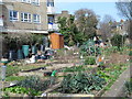
Allotments by the path between Green Lanes and Clissold Crescent, N16
Image: © Mike Quinn
Taken: 11 Mar 2015
0.08 miles