IMAGES TAKEN NEAR TO
Walmington Fold, LONDON, N12 7LJ
Introduction
This page details the photographs taken nearby to Walmington Fold, N12 7LJ by members of the Geograph project.
The Geograph project started in 2005 with the aim of publishing, organising and preserving representative images for every square kilometre of Great Britain, Ireland and the Isle of Man.

There are currently over 7.5m images from over14,400 individuals and you can help contribute to the project by visiting https://www.geograph.org.uk
Image Map
Images are licensed for reuse under creativecommons.org/licenses/by-sa/2.0
Notes
- Clicking on the map will re-center to the selected point.
- The higher the marker number, the further away the image location is from the centre of the postcode.
Image Listing (8 Images Found)
Images are licensed for reuse under creativecommons.org/licenses/by-sa/2.0
Image
Details
Distance
1
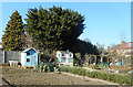
Desirable Properties on the Allotments
Sheds to be proud of on these well kept allotments beside the Dollis Brook.
Image: © Des Blenkinsopp
Taken: 26 Feb 2019
0.06 miles
4

Dollis Brook and Greenwalk in Finchley
The Dollis Valley Greenwalk is a 16km route linking the London Loop and Capital Ring long distance paths. A lot of its route was laid out as the Brookside Walk in the 1930s by the former Borough of Finchley. https://en.wikipedia.org/wiki/Dollis_Valley_Greenwalk
Image: © Des Blenkinsopp
Taken: 26 Feb 2019
0.09 miles
5
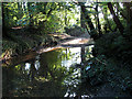
Dollis Brook
Sunlight streams through the trees in this early morning view of the brook.
Image: © Martin Addison
Taken: 1 Aug 2007
0.18 miles
6
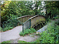
Bridge over Dollis Brook
One of many footbridges over the brook, unusually this one is arched. The flat 'bridge' adjacent probably carries electricity cables or water pipes across the brook.
Image: © Martin Addison
Taken: 1 Aug 2007
0.21 miles
7
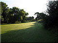
Open Ground Behind Brent Way
Taken from the footpath between Nether Street and Frith Lane, the ground slopes sharply down towards Dollis Brook on the left of the photo. There is a heavy dew on the grass and Wood Pigeons can be seen searching for early morning snacks.
Image: © Martin Addison
Taken: 1 Aug 2007
0.21 miles
8
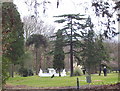
Nether Court Grounds
Nether court had extensive grounds created by Henry Tubbs, as he was a Canadian timber magnate the grounds have a fantastic selection of trees of the world.
These have been improved and enhanced by the golf club.
Image: © Robert Timms
Taken: 20 Feb 2006
0.23 miles