IMAGES TAKEN NEAR TO
Devon Close, CHATHAM, ME5 7SJ
Introduction
This page details the photographs taken nearby to Devon Close, ME5 7SJ by members of the Geograph project.
The Geograph project started in 2005 with the aim of publishing, organising and preserving representative images for every square kilometre of Great Britain, Ireland and the Isle of Man.

There are currently over 7.5m images from over14,400 individuals and you can help contribute to the project by visiting https://www.geograph.org.uk
Image Map
Images are licensed for reuse under creativecommons.org/licenses/by-sa/2.0
Notes
- Clicking on the map will re-center to the selected point.
- The higher the marker number, the further away the image location is from the centre of the postcode.
Image Listing (33 Images Found)
Images are licensed for reuse under creativecommons.org/licenses/by-sa/2.0
Image
Details
Distance
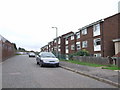
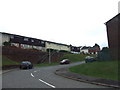
2
Princes Park
Photographer facing Hampshire Close, standing on Princes Avenue at junction of North Dane Way.
Image: © Danny P Robinson
Taken: 9 Apr 2006
0.09 miles
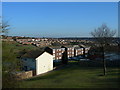
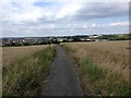
3
Shawstead Road, near Luton
This stretch of Shawstead Road was rendered obsolete by the construction of North Dane Way in the 1970s.
Image: © Chris Whippet
Taken: 18 Dec 2013
0.09 miles
4
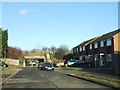
Kingfisher Drive, Princes Park
The underpass (underneath Heron Way) leads to Hopewell Drive. Both Kingfisher Drive and Hopewell Drive originally formed part of Princes Avenue.
Image: © Chris Whippet
Taken: 17 Dec 2008
0.10 miles
7
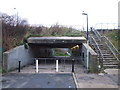
Pedestrian Subway between Kingfisher Drive and Hopewell Drive, Princes Park
Passing underneath Heron Way, both Kingfisher Drive and Hopewell Drive used to form part of Princes Avenue.
Image: © Chris Whippet
Taken: 18 Dec 2013
0.11 miles
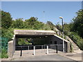
8
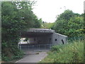
Underpass between Kingfisher Drive and Hopewell Drive
Kingfisher Drive and Hopewell Drive were formerly known as Princes Avenue. The underpass came into existence after the construction of Heron Way in the late 1970s.
Image: © Chris Whippet
Taken: 15 Jul 2014
0.11 miles
9
Subway under Heron Way
This subway is used to link Hopewell Drive to Kingfisher Drive.
Image: © David Anstiss
Taken: 23 Jul 2012
0.11 miles
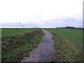
10
Shawstead Road, near Luton
This stretch of road used to lead from the junction of Shawstead Road and Lordswood Lane down to East Hill in Luton before the construction of North Dane Way in the early 1970s rendered it obsolete.
Image: © Chris Whippet
Taken: 25 Jul 2017
0.11 miles