IMAGES TAKEN NEAR TO
Buckland, FAVERSHAM, ME13 0TW
Introduction
This page details the photographs taken nearby to ME13 0TW by members of the Geograph project.
The Geograph project started in 2005 with the aim of publishing, organising and preserving representative images for every square kilometre of Great Britain, Ireland and the Isle of Man.

There are currently over 7.5m images from over14,400 individuals and you can help contribute to the project by visiting https://www.geograph.org.uk
Image Map
Images are licensed for reuse under creativecommons.org/licenses/by-sa/2.0
Notes
- Clicking on the map will re-center to the selected point.
- The higher the marker number, the further away the image location is from the centre of the postcode.
Image Listing (28 Images Found)
Images are licensed for reuse under creativecommons.org/licenses/by-sa/2.0
Image
Details
Distance
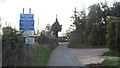
2
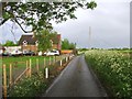
The lane to Luddenham
This is the view looking along the lane to Luddenham just beyond the junction with Lower Road near the level crossing. The Swale between the mainland and the Isle of Sheppey lies in the distance, with Sheppey on the horizon.
Image: © Marathon
Taken: 5 Mar 2013
0.09 miles
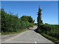
3
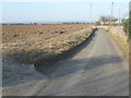
Country lane near Faversham
A lane through Kent countryside near Faversham.
This road is on the route of National Cycle Network route 1, which stretches from Dover to John o'Groats.
Image: © Malc McDonald
Taken: 26 Oct 2013
0.13 miles
4
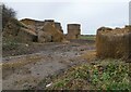
Rather soggy stacks of hay, Luddenham
By Lower Road, next to Stone Crossing.
Image: © pam fray
Taken: 3 Jan 2022
0.14 miles
5
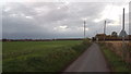
Country Lane near Faversham
A lane through Kent coutnryside near Faversham. Here the lane approaches a level crossing.
This road is on the route of National Cycle Network route 1, which stretches from Dover to John o'Groats.
Image: © Malc McDonald
Taken: 26 Oct 2013
0.15 miles
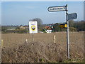
6
On National Cycle Route 1.
Towards Elverton.
Image: © JThomas
Taken: 22 Jun 2022
0.15 miles
7
Looking towards Stone Farm
This is the view from Lower Road just beyond the level crossing and looks towards Stone Farm.
Image: © Marathon
Taken: 5 Mar 2013
0.17 miles
8
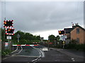
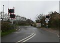
Level Crossing, Lower Road, near Luddenham
Image: © Chris Whippet
Taken: 19 May 2015
0.18 miles
9
Stone Crossing, near Faversham
Off Lower Road, Luddenham.
Image: © pam fray
Taken: 3 Jan 2022
0.18 miles
10
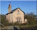
Former crossing keeper's house, Lower Road
Next to the level crossing on the busy North Kent railway line between Teynham and Faversham, the old level crossing keeper's house is now derelict. The garden is completely overgrown and fenced in. The crossing has now been converted to half-barrier automatic operation.
Image: © Marathon
Taken: 5 Mar 2013
0.18 miles