IMAGES TAKEN NEAR TO
Warden Road, SHEERNESS, ME12 4HG
Introduction
This page details the photographs taken nearby to Warden Road, ME12 4HG by members of the Geograph project.
The Geograph project started in 2005 with the aim of publishing, organising and preserving representative images for every square kilometre of Great Britain, Ireland and the Isle of Man.

There are currently over 7.5m images from over14,400 individuals and you can help contribute to the project by visiting https://www.geograph.org.uk
Image Map
Images are licensed for reuse under creativecommons.org/licenses/by-sa/2.0
Notes
- Clicking on the map will re-center to the selected point.
- The higher the marker number, the further away the image location is from the centre of the postcode.
Image Listing (40 Images Found)
Images are licensed for reuse under creativecommons.org/licenses/by-sa/2.0
Image
Details
Distance
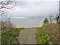
1
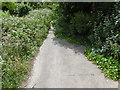
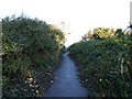
Former road at Warden Point
The road is marked brown on the Ordnance Map so it was quite important once but just before it reaches the edge of the cliff at Warden Point, behind where I am standing, it disappears into the void. For the view at the cliff edge see http://www.geograph.org.uk/photo/5020391
Image: © Marathon
Taken: 3 Jul 2016
0.01 miles
5
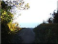
Warden Point
This picture has been taken at the very end of Warden Road where cliff erosion is slowly reclaiming the area to the sea.
Image: © Chris Whippet
Taken: 23 Nov 2013
0.05 miles
6
Warden Point
This picture has been taken at the very end of Warden Road where cliff erosion is slowly reclaiming the area to the sea.
Image: © Chris Whippet
Taken: 23 Nov 2013
0.05 miles
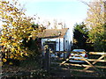
7
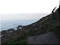
Warden Point
This picture has been taken at the very end of Warden Road where cliff erosion is slowly reclaiming the area to the sea. The remains of a concrete bunker can be seen on the beach below.
Image: © Chris Whippet
Taken: 23 Nov 2013
0.05 miles
8
Warden Point
This picture has been taken at the very end of Warden Road where cliff erosion is slowly reclaiming the area to the sea. The remains of a concrete bunker can be seen on the beach below.
Image: © Chris Whippet
Taken: 23 Nov 2013
0.05 miles

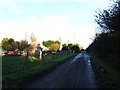
10
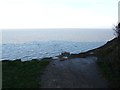
The end of the road, Warden Point
The London Clay cliffs here are eroding rather rapidly. This road continued to the church once, and beyond, but the church, built about 1595, was abandoned and partly dismantled in the 19th century. Its remains went over the cliff in about 1880. Its site is now about 250 m beyond this current end of the road, although if its remains slithered down the slope as more recent buildings have, they would be even further out to sea. The 1595 church replaced an earlier church whose site is suggested to be further along the former road about a mile out to sea now.
Image: © Robin Webster
Taken: 6 Mar 2016
0.06 miles