IMAGES TAKEN NEAR TO
New Road, SHEERNESS, ME12 3PT
Introduction
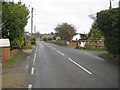
This page details the photographs taken nearby to New Road, ME12 3PT by members of the Geograph project.
The Geograph project started in 2005 with the aim of publishing, organising and preserving representative images for every square kilometre of Great Britain, Ireland and the Isle of Man.

There are currently over 7.5m images from over14,400 individuals and you can help contribute to the project by visiting https://www.geograph.org.uk
Image Map
Images are licensed for reuse under creativecommons.org/licenses/by-sa/2.0
Notes
- Clicking on the map will re-center to the selected point.
- The higher the marker number, the further away the image location is from the centre of the postcode.
Image Listing (120 Images Found)
Images are licensed for reuse under creativecommons.org/licenses/by-sa/2.0
Image
Details
Distance
1
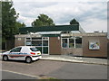
Minster Library, Minster
On Worcester Close.
Image: © David Anstiss
Taken: 10 Jul 2009
0.14 miles
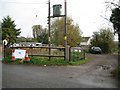
2
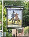
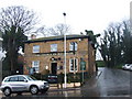
Pub sign: The Prince of Waterloo, Minster-in-Sheppey
The pub sign is still up, but the building is undergoing major refurbishment. Whether the place will re-open as a pub I can't say - but anyone with a thirst has a choice of two pubs just a minute's walk away.
Image: © Stefan Czapski
Taken: 29 Jul 2017
0.15 miles
3
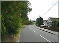
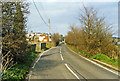
Scocles Road, Minster
With Southlees Marshes faintly seen in the distance
Image: © John Baker
Taken: 22 Aug 2012
0.17 miles
4
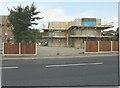
362, Minster Road, Minster-on-Sea
Planning permission has been granted by Swale Borough Council under application number SW/13/1038 for a “dropped kerb and driveway with permeable surfacing”.
Image: © John Baker
Taken: 29 Sep 2013
0.17 miles
5
Sheppey Light Railway: Site of the former Scocles Road crossing
The Sheppey Light Railway ran from Queenborough to Leysdown-on-Sea. It was built to the designs of the renowned light railway engineer, Colonel Fred Holman Stephens, and was opened in 1901. Traffic was never busy on the line and it was taken over by the South Eastern and Chatham Railway in 1905, finally closing in 1950.
The railway would have crossed over Scocles Road here, but not quite at right angles to it, at about where the cones are on the right. Image was just to the right. A house has now been built on the route of the railway to the left of the old crossing here but its site boundaries match the old boundary of the railway, so are not perpendicular to the road.
Image: © Nigel Cox
Taken: 24 Nov 2013
0.18 miles
6
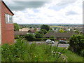
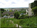
View south from Minster High Street
Minster Abbey is named after a Saxon nunnery here which was founded in 664AD and sacked by the Danes in 835. This was re-established about 1130, when the present church was built, incorporating and still showing parts of its Saxon predecessor. It is located on the highest point of the Isle of Sheppey and gives superb views to the south across the island and beyond The Swale to the mainland. A full description of the Abbey can be found at http://www.minsterabbey.org.uk/3.html
This view is from High Street, just to the south of the churchyard. The hills on the horizon are on the mainland.
Image: © Marathon
Taken: 3 Jul 2016
0.18 miles
8
Site of former Minster-on-Sea station, 1995
View NNE on Scocles Road, towards Minster-on-Sea: ex-SE&CR Sheppey (Queenborough - Leysdown) Light Railway, all closed 4/12/50.
Image: © Ben Brooksbank
Taken: 11 Mar 1995
0.18 miles
9
Sheppey Light Railway: Site of the former Minster on Sea station
The Sheppey Light Railway ran from Queenborough to Leysdown-on-Sea. It was built to the designs of the renowned light railway engineer, Colonel Fred Holman Stephens, and was opened in 1901. Traffic was never busy on the line and it was taken over by the South Eastern and Chatham Railway in 1905, finally closing in 1950.
The former Minster on Sea station would have been about where the tree is beyond the double power poles. Looking at old maps it is easy to see why the railway failed to thrive. When it was built the nearest house was over 500 metres away up the hill in Minster.
Image: © Nigel Cox
Taken: 24 Nov 2013
0.18 miles
10
View southwards from Minster High Street
Minster Abbey is named after a Saxon nunnery here which was founded in 664AD and sacked by the Danes in 835. This was re-established about 1130, when the present church was built, incorporating and still showing parts of its Saxon predecessor. It is located on the highest point of the Isle of Sheppey and gives superb views to the south across the island and beyond The Swale to the mainland. A full description of the Abbey can be found at http://www.minsterabbey.org.uk/3.html
This view is from High Street, just to the south of the churchyard. The hills on the horizon are on the mainland. The building on the right hand side is the edge of the former Fultons Newsagents - see http://www.geograph.org.uk/photo/4853873
Image: © Marathon
Taken: 3 Jul 2016
0.19 miles