IMAGES TAKEN NEAR TO
ME10 3SZ
Introduction
This page details the photographs taken nearby to ME10 3SZ by members of the Geograph project.
The Geograph project started in 2005 with the aim of publishing, organising and preserving representative images for every square kilometre of Great Britain, Ireland and the Isle of Man.

There are currently over 7.5m images from over14,400 individuals and you can help contribute to the project by visiting https://www.geograph.org.uk
Image Map
Images are licensed for reuse under creativecommons.org/licenses/by-sa/2.0
Notes
- Clicking on the map will re-center to the selected point.
- The higher the marker number, the further away the image location is from the centre of the postcode.
Image Listing (137 Images Found)
Images are licensed for reuse under creativecommons.org/licenses/by-sa/2.0
Image
Details
Distance
2
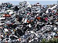
Whataloadarubbish . . . by Milton Creek
There's an awful lot of it, and I hope it's going to get re-cycled, somehow or other. The only item I can identify is a Bosch lawn-mower (blue-green and orange, near the left hand margin, about one third of the way up).
In case anyone's wondering, it wasn't this rubbish-mountain I came looking for near Milton Creek - I thought there was a sailing barge museum somewhere nearby, but it appears that it was destroyed by a disastrous fire.
Afterthought: I strongly suspect that the junk in the picture was due to be re-cycled by SWEEEP (the Specialist Waste Electrical and Electronic Equipment Processor) - see the various contributions by Richard Dorrell: http://www.geograph.org.uk/photo/735712
Image: © Stefan Czapski
Taken: 26 Jun 2012
0.06 miles
3
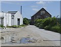
Blocked footpath to Crown Quay, Sittingbourne
A path leads from Eurolink Way (beside a retail park - on the left) and then it should lead to a road through the disused Crown Quay industrial estate (near the Milton Creek).
But this is not used very frequently and buddleia have grown-up to block the path.
On the right is Image
Image: © David Anstiss
Taken: 16 Feb 2013
0.08 miles
4
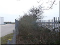
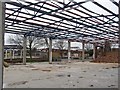
Development site, Crown Quay Lane
Planning permission has been granted by Swale Borough Council under application number 16/507877/FULL for the “erection of a residential development comprising 405 dwellings including associated access, parking, public open spaces and landscaping. New vehicular/pedestrian access from Eurolink Way and further secondary vehicular/pedestrian access off Crown Quay Lane. Associated drainage and earthworks”. The location was described as land to the west of Crown Quay Lane.
The site is bounded, along Crown Quay Lane, by a tall, steel fence but it was possible to angle the camera to get a clear view. There is still an issue of flooding but a lot of rain had fallen in previous weeks, prior to this view.
This was the Image in October 2017.
Image: © John Baker
Taken: 23 Dec 2019
0.09 miles
5
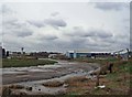
Demolition in Crown Quay Lane
The former industrial sites in Crown Quay estate are being demolished to begin the redevelopment of the area between Crown Quay Lane and the Creek for residential and community open space.
Image: © Richard Dorrell
Taken: 24 Mar 2008
0.10 miles
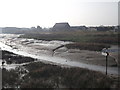
6
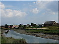
Milton Creek, Sittingbourne
Once an important waterway, but now unused and probably unknown to most Sittingbourne residents. The water tower and buildings around it are at Sittingbourne Mill.
Image: © Richard Dorrell
Taken: 24 Mar 2008
0.11 miles
8
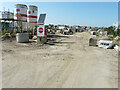
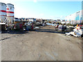
Development site, Crown Quay Lane
Planning permission has been granted by Swale Borough Council under application number 16/507877/FULL for the “erection of a residential development comprising 405 dwellings including associated access, parking, public open spaces and landscaping. New vehicular/pedestrian access from Eurolink Way and further secondary vehicular/pedestrian access off Crown Quay Lane. Associated drainage and earthworks”. The location was described as land to the west of Crown Quay Lane.
This was the Image in December 2019, when part of the site was under water.
Image: © John Baker
Taken: 16 Sep 2021
0.11 miles
9
Milton Creek, looking mouthwards
This creek flows between Sittingbourne and Kemsley where it joins the Swale.
Seen from the Saxon Shore Way (long distance path) within Milton Creek Country Park.
Image: © David Anstiss
Taken: 22 Mar 2012
0.11 miles
10
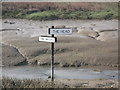
The Head and Mouth of Milton Creek
This sign within the creek points right to the Head of the creek, within Sittingbourne. It also points left to the Mouth of the creek, where it joins the Swale, near Kemsley.
Seen from the Saxon Shore Way (long distance path) in Milton Creek Country Park.
Image: © David Anstiss
Taken: 22 Mar 2012
0.11 miles