IMAGES TAKEN NEAR TO
Eurolink Industrial Centre, Castle Road, SITTINGBOURNE, ME10 3FP
Introduction
This page details the photographs taken nearby to Eurolink Industrial Centre, Castle Road, ME10 3FP by members of the Geograph project.
The Geograph project started in 2005 with the aim of publishing, organising and preserving representative images for every square kilometre of Great Britain, Ireland and the Isle of Man.

There are currently over 7.5m images from over14,400 individuals and you can help contribute to the project by visiting https://www.geograph.org.uk
Image Map
Images are licensed for reuse under creativecommons.org/licenses/by-sa/2.0
Notes
- Clicking on the map will re-center to the selected point.
- The higher the marker number, the further away the image location is from the centre of the postcode.
Image Listing (33 Images Found)
Images are licensed for reuse under creativecommons.org/licenses/by-sa/2.0
Image
Details
Distance
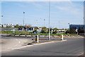
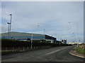
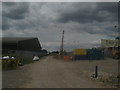
5
Roundabout on Castle Road
Within the Eurolink Industrial Estate. Castle Road leads from Eurolink Way (in central Sittingbourne) to here, then Swale Way heads right towards the Great Easthall Housing Estate / development. An exit left has been left for the construction of the Sittingbourne Northern Relief Road. In the background on the left is Marshalls (brick and concrete product warehouse).
Image: © David Anstiss
Taken: 16 Jan 2010
0.09 miles
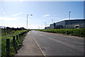
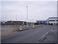
7
New road works near Castle Way
This road construction work is on the Sittingbourne Northern Relief Road heading into Eurolink Industrial Estate.
Image: © David Anstiss
Taken: 17 Jul 2010
0.12 miles
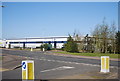
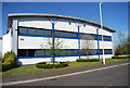
8
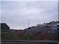
The route of Sittingbourne North Relief Road to Milton Creek
Within the Eurolink Industrial Estate, a gap was made between plots for the later construction of this road. Seen from the roundabout on Castle Road. This new road will provide a direct link to the A249 dual carriageway, bypassing central Sittingbourne. Construction of this road has just started.
Image: © David Anstiss
Taken: 16 Jan 2010
0.12 miles