IMAGES TAKEN NEAR TO
Meanwood Grove, LEEDS, LS6 4QQ
Introduction
This page details the photographs taken nearby to Meanwood Grove, LS6 4QQ by members of the Geograph project.
The Geograph project started in 2005 with the aim of publishing, organising and preserving representative images for every square kilometre of Great Britain, Ireland and the Isle of Man.

There are currently over 7.5m images from over14,400 individuals and you can help contribute to the project by visiting https://www.geograph.org.uk
Image Map
Images are licensed for reuse under creativecommons.org/licenses/by-sa/2.0
Notes
- Clicking on the map will re-center to the selected point.
- The higher the marker number, the further away the image location is from the centre of the postcode.
Image Listing (58 Images Found)
Images are licensed for reuse under creativecommons.org/licenses/by-sa/2.0
Image
Details
Distance
1
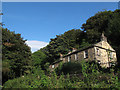
Houses on Meanwood Grove
Seen from the footpath below the road.
Image: © Stephen Craven
Taken: 17 Sep 2016
0.00 miles
2
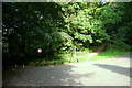
Road closure, Parkside Road, Meanwood, Leeds
"When I used to come here, years ago, Parkside Road was a handy rat-run between Meanwood and the outer ring road – though a little hair-raising as the switchback-style road plunged down through the dark woods. Its (The Myrtle) location guaranteed a deal of passing trade, and made it handy as a meeting place for the after-work crowd. Two things changed that – one end of the road was diverted to force drivers through a tortuous chicane and over some speed bumps; the other end was simply closed. The through traffic was forced to go some other route, and rather than being ready stopping-off points for passing motorists the Myrtle and its near neighbour the Bay Horse were suddenly off the beaten track."
Quoted from http://www.yorkshireeveningpost.co.uk/lifestyle/bars/pub-review-the-myrtle-tavern-parkside-road-meanwood-1-4023030
Image: © Humphrey Bolton
Taken: 17 Sep 2016
0.02 miles
3
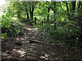
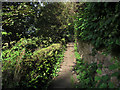
Footpath below Meanwood Grove
Meanwood Grove is a vehicular road (though possibly private) but for some reason the public footpath runs parallel to it in the field just below. It is however overgrown a short way on, and we needed to turn back and take the road.
Image: © Stephen Craven
Taken: 17 Sep 2016
0.02 miles
4
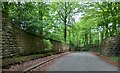
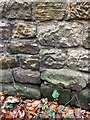
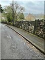
Northern end of Parkside Road, Weetwood, Leeds
There is a benchmark cut into the roadside wall on the west side of Parkside Road and to the right of the wall junction. Closer view Image]
Image: © Mel Towler
Taken: 14 May 2023
0.04 miles
5
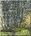
Benchmark Parkside Road, Meanwood
Benchmark description https://www.bench-marks.org.uk/bm135514
Image: © OfficeOfPudseyBMs
Taken: 12 Nov 2020
0.04 miles
6
Benchmark cut into roadside wall, Weetwood, Leeds
The benchmark is cut into a roadside wall on the west side of Parkside Road and to the right of a wall junction. Wider view Image]
Image: © Mel Towler
Taken: 14 May 2023
0.04 miles
7
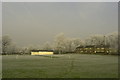
Meanwood Cricket Club
Looking north between Wood Nook and the Myrtle Public House towards Parkside Road.
Image: © Martin Rankin
Taken: 20 Feb 2008
0.06 miles
8
Meanwood Grove
Further to the north-east the route is a vehicular road but here it is merely a stone flagged footpath.
Image: © Stephen Craven
Taken: 17 Sep 2016
0.06 miles
9
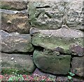
Meanwood, Parkside Road
There is a benchmark cut into a right-hand stone gatepost on the east side of the road.
Image: © Mel Towler
Taken: 12 Apr 2022
0.07 miles
10
Meanwood, Parkside Road
The benchmark is cut into a right-hand stone gatepost on the east side of the road.
Image: © Mel Towler
Taken: 12 Apr 2022
0.07 miles