IMAGES TAKEN NEAR TO
Thorp Arch, WETHERBY, LS23 7DS
Introduction
This page details the photographs taken nearby to LS23 7DS by members of the Geograph project.
The Geograph project started in 2005 with the aim of publishing, organising and preserving representative images for every square kilometre of Great Britain, Ireland and the Isle of Man.

There are currently over 7.5m images from over14,400 individuals and you can help contribute to the project by visiting https://www.geograph.org.uk
Image Map
Images are licensed for reuse under creativecommons.org/licenses/by-sa/2.0
Notes
- Clicking on the map will re-center to the selected point.
- The higher the marker number, the further away the image location is from the centre of the postcode.
Image Listing (8 Images Found)
Images are licensed for reuse under creativecommons.org/licenses/by-sa/2.0
Image
Details
Distance
1
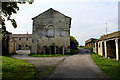
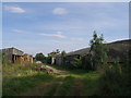
Flint Mill Grange
Large property high above the River Wharfe - seen here with the Ebor Way long distance footpath passing between outbuildings.
Image: © Chris Heaton
Taken: 11 Oct 2015
0.01 miles
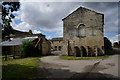
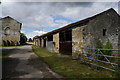
4
Flint Mill Grange
Grade 2 listed eighteenth century property with barns. The approach lane here is part of the Ebor way. Beyond the barns is mud of a particularly unpleasant and slippery kind.
Image: © Gordon Hatton
Taken: 7 Mar 2022
0.03 miles
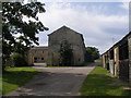
7
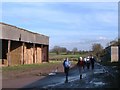
Ebor Way at Flint Mill Grange
Walkers on the Ebor Way pass by barns at Flint Mill Grange between Wetherby and Thorpe Arch.
Image: © Gordon Hatton
Taken: 24 Feb 2011
0.04 miles
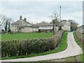
8
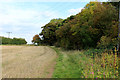
Ebor Way West of Flint Mill Grange
The long distance footpath follows the field edge, rather than the route indicated on the definitive map
Image: © Chris Heaton
Taken: 11 Oct 2015
0.23 miles