IMAGES TAKEN NEAR TO
Glebe Field Close, WETHERBY, LS22 5RA
Introduction
This page details the photographs taken nearby to Glebe Field Close, LS22 5RA by members of the Geograph project.
The Geograph project started in 2005 with the aim of publishing, organising and preserving representative images for every square kilometre of Great Britain, Ireland and the Isle of Man.

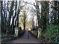
There are currently over 7.5m images from over14,400 individuals and you can help contribute to the project by visiting https://www.geograph.org.uk
Image Map
Images are licensed for reuse under creativecommons.org/licenses/by-sa/2.0
Notes
- Clicking on the map will re-center to the selected point.
- The higher the marker number, the further away the image location is from the centre of the postcode.
Image Listing (109 Images Found)
Images are licensed for reuse under creativecommons.org/licenses/by-sa/2.0
Image
Details
Distance
1
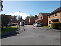
Glebe Field Close - Glebe Field Drive
Image: © Betty Longbottom
Taken: 3 May 2016
0.03 miles
2
Harland Way - Wetherby triangle
The Harland way is a cycle route built by Sustrans on the former Harrogate to Tadcaster railway. This is a section of the Wetherby triangle. Ahead leads towards Harrogate; behind used to be to Garforth, but now only leads to a car park.
Image: © DS Pugh
Taken: 7 Jul 2007
0.04 miles
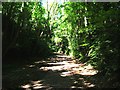
3
Harland Way on Quarry Hill
Running through a cutting towards the bridge shown in Image
Image: © Derek Harper
Taken: 6 Apr 2015
0.05 miles
4
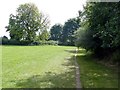
Field path in Wetherby
On the line of a former railway linking lines to Leeds and Harrogate
Image: © Graham Hogg
Taken: 16 Aug 2016
0.05 miles
5
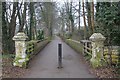
Path towards Hill Top
Seen from Quarry Hill Lane. Old maps show a large house named Hill Top - these, presumably, were its entrance gate-posts.
Image: © E Gammie
Taken: 30 Dec 2016
0.05 miles
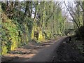
6
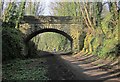
Bridge over disused railway near Wetherby
The bridge, which links Quarry Hill Lane to the Hill Top estate, is also shown in Image and, from above, in Image The Harland Way follows the former railway to Spofforth.
Image: © Derek Harper
Taken: 6 Apr 2015
0.06 miles
7
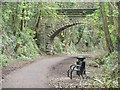
Anonymous bridge over the Harland Way
The Leeds section of this cycle and footpath route [a former railway line] is well-equipped with benches and bins.
Image: © Christine Johnstone
Taken: 8 Apr 2012
0.06 miles
8
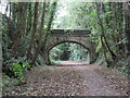
Bridge over dismantled railway, Wetherby
This wooded cutting in Wetherby is the route of a railway which closed in 1964. It linked Leeds and Wetherby with Harrogate and places beyond. The route is now a path open to pedestrians and cyclists. It forms part of route 67 of the National Cycle Network.
The bridge ahead carries a minor road over the former railway.
Image: © Malc McDonald
Taken: 14 Oct 2021
0.06 miles
9
Bridge Over The Harland Way
View from Quarry Hill Lane. The trackbed of the former "New Wetherby Curve" railway line, now a cycle track, runs beneath the bridge.
Image: © David Rogers
Taken: 7 Mar 2013
0.07 miles
10
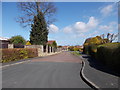
Overdale Close - viewed from Lazenby Drive
Image: © Betty Longbottom
Taken: 3 May 2016
0.08 miles