IMAGES TAKEN NEAR TO
Piebridge Way, LEEDS, LS12 6ES
Introduction
This page details the photographs taken nearby to Piebridge Way, LS12 6ES by members of the Geograph project.
The Geograph project started in 2005 with the aim of publishing, organising and preserving representative images for every square kilometre of Great Britain, Ireland and the Isle of Man.

There are currently over 7.5m images from over14,400 individuals and you can help contribute to the project by visiting https://www.geograph.org.uk
Image Map
Images are licensed for reuse under creativecommons.org/licenses/by-sa/2.0
Notes
- Clicking on the map will re-center to the selected point.
- The higher the marker number, the further away the image location is from the centre of the postcode.
Image Listing (59 Images Found)
Images are licensed for reuse under creativecommons.org/licenses/by-sa/2.0
Image
Details
Distance
1
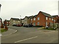
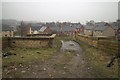
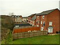
Piebridge Way
These houses are a recent development on the site of the LNWR's Farnley and Wortley Engine Shed (built 1882, I haven't found the date of closure but probably before the end of steam in 1967). See https://westleedsdispatch.com/marks-history-reminders-of-past-in-new-wortley-housing-estate/ for more background.
Image: © Stephen Craven
Taken: 31 Jan 2021
0.02 miles
2
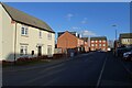
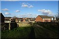
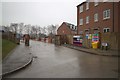
NEW
Piebridge Way
A street in a recent housing development. A footpath runs from here to Gelderd Road.
Image: © DS Pugh
Taken: 22 Feb 2025
0.03 miles
4
Path down to Honeybourne Road
The public footpath crosses an old railway bridge then descends to a new housing estate built on former railway land.
Image: © Stephen Craven
Taken: 31 Jan 2021
0.03 miles
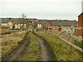
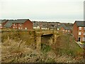
5
Bridge over disused railway line
Looking over the roof tops of the Royds Lane Mount housing development.
Image: © Mark Anderson
Taken: 15 Mar 2018
0.04 miles
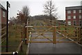
6
NEW
Footpath to Uppingham Gardens
A path crossing a bridge over the former Farnley and Wortley Branch railway line.
Image: © DS Pugh
Taken: 22 Feb 2025
0.04 miles
7
Footbridge off Honeybourne Road
The bridge crosses the course of a former freight railway line, and originally gave access to two small coal pits on this side. It now carries a public footpath to Gelderd Road, as well as giving access to grazing land Image It was cleaned up as part of the recent housing development on former railway land. See also Image A photo of it pre-restoration can be seen at https://westleedsdispatch.com/marks-history-reminders-of-past-in-new-wortley-housing-estate/
Image: © Stephen Craven
Taken: 31 Jan 2021
0.04 miles
8
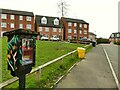
Little Free Library, Uppingham Gardens
One of several such local book exchanges in Leeds.
Image: © Stephen Craven
Taken: 31 Jan 2021
0.05 miles
9
Gardens on the line of an old railway
The back gardens of the houses on Uppingham Gardens occupy the route of a former freight line to the Farnley Ironworks.
Image: © Stephen Craven
Taken: 31 Jan 2021
0.06 miles
10
Pullman Crescent (under construction)
Part of the Royds Lane Mount housing development. The road follows the route of a disused railway line.
Image: © Mark Anderson
Taken: 15 Mar 2018
0.06 miles