IMAGES TAKEN NEAR TO
Havelock Street, LEICESTER, LE2 7HA
Introduction
This page details the photographs taken nearby to Havelock Street, LE2 7HA by members of the Geograph project.
The Geograph project started in 2005 with the aim of publishing, organising and preserving representative images for every square kilometre of Great Britain, Ireland and the Isle of Man.

There are currently over 7.5m images from over14,400 individuals and you can help contribute to the project by visiting https://www.geograph.org.uk
Image Map
Images are licensed for reuse under creativecommons.org/licenses/by-sa/2.0
Notes
- Clicking on the map will re-center to the selected point.
- The higher the marker number, the further away the image location is from the centre of the postcode.
Image Listing (159 Images Found)
Images are licensed for reuse under creativecommons.org/licenses/by-sa/2.0
Image
Details
Distance
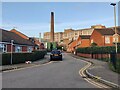
1
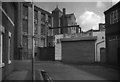
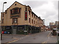
Factory Rydal Street Leicester
Typical of the older mix of housing, factories and scrapyards between the Royal Infirmary and Narborough Road. Expansion of the Infirmary and De Montfort University has led to redevelopment of this area for student housing, bars and shops.
Image: © Terry Roberts
Taken: Unknown
0.02 miles
2
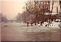
Walking on water
In Leicester in December 1981, it was so cold (-15c at night, -5c in day) that the Grand Union Canal/ River Soar froze solid.
Image: © Peter Craine
Taken: Unknown
0.02 miles
3
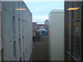
Rooftops
Looking from a fifth floor window across the rooftops at Leicester Royal Infirmary
Image: © cris sloan
Taken: 18 Dec 2006
0.02 miles
4
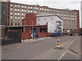
Leicester - Royal Infirmary
Part of the rear of Leicester Royal Infirmary taken from Havelock Street.
Image: © David Hallam-Jones
Taken: 31 Mar 2012
0.04 miles
5
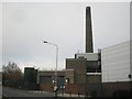
Leicester Royal Infirmary
Chimney Stack, looking from Havelock Street.
Image: © Ian Rob
Taken: 19 Nov 2011
0.04 miles
7
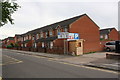
Housing and car park on SW side of Havelock Street
Ordnance Survey documents indicate that in 1965 a benchmark levelled at 56.827m above Newlyn Datum was verified on a fire goods factory at this location
Image: © phil Richards
Taken: 16 Jun 2017
0.06 miles
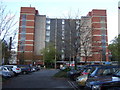
9
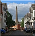
Martindale Close in Leicester
The chimney is part of the Leicester Royal Infirmary.
Image: © Mat Fascione
Taken: 13 May 2020
0.07 miles
10
Leicester - Royal Infirmary vicinity
"The Font" at the Junction of Deacon Street and Havelock Street now occupies the premises once owned by Harrison & Hayes (Hosiery Manufacturers).
Image: © David Hallam-Jones
Taken: 31 Mar 2012
0.09 miles