IMAGES TAKEN NEAR TO
Evington Footway, LEICESTER, LE2 1QP
Introduction
This page details the photographs taken nearby to Evington Footway, LE2 1QP by members of the Geograph project.
The Geograph project started in 2005 with the aim of publishing, organising and preserving representative images for every square kilometre of Great Britain, Ireland and the Isle of Man.

There are currently over 7.5m images from over14,400 individuals and you can help contribute to the project by visiting https://www.geograph.org.uk
Image Map
Images are licensed for reuse under creativecommons.org/licenses/by-sa/2.0
Notes
- Clicking on the map will re-center to the selected point.
- The higher the marker number, the further away the image location is from the centre of the postcode.
Image Listing (159 Images Found)
Images are licensed for reuse under creativecommons.org/licenses/by-sa/2.0
Image
Details
Distance
1
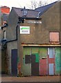
Evington Footway, Leicester
Originally a rural footpath to the village of Evington, the urban end has survived the 19th and 20th century development of the City. It has even been provided with proper cast-iron name signs.
Image: © Alan Murray-Rust
Taken: 26 Jan 2019
0.01 miles
2
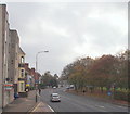
London Road, Leicester
The section of London Road (the A6) between Evington Road and The Old Horse public house, with the north-eastern boundary of Victoria Park on the right. The city centre lies 4-5 minutes drive away, behind the photographer.
Image: © David Hallam-Jones
Taken: 30 Oct 2014
0.03 miles
4
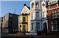
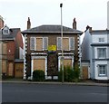
Victoria House, 172/174 London Road
Original a pair of early 19th century houses, Regency style, Listed Grade II.
Image: © Alan Murray-Rust
Taken: 26 Jan 2019
0.05 miles
5
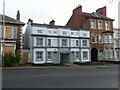
170 London Road, Leicester
Early 19th century, Regency style house, Listed Grade II. Looking sorry for itself at the time of my visit.
Image: © Alan Murray-Rust
Taken: 26 Jan 2019
0.05 miles
6
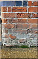
Benchmark on #156 London Road
Ordnance Survey cut mark benchmark described on the Bench Mark Database at www.bench-marks.org.uk/bm88457
Image: © phil Richards
Taken: 9 Sep 2017
0.05 miles
7
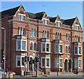
Leicester - houses at Evington Road junction with London Road
Image: © Dave Bevis
Taken: 16 Feb 2014
0.05 miles
8
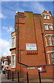
Houses at junction of London Road and Evington Footway
There is an Ordnance Survey benchmark Image on the nearest house wall between the 2nd and 3rd black posts from the left hand end of the row
Image: © phil Richards
Taken: 9 Sep 2017
0.06 miles
9
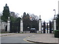
Victoria Park gates, Leicester
The entrance gates to Victoria Park in Leicester.
Image: © Malc McDonald
Taken: 27 Feb 2011
0.06 miles
10
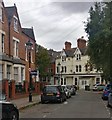
St Albans Road in Highfields, Leicester
Image: © Mat Fascione
Taken: 23 Sep 2019
0.07 miles