IMAGES TAKEN NEAR TO
Sheriff Well Close, ULVERSTON, LA12 7RU
Introduction
This page details the photographs taken nearby to Sheriff Well Close, LA12 7RU by members of the Geograph project.
The Geograph project started in 2005 with the aim of publishing, organising and preserving representative images for every square kilometre of Great Britain, Ireland and the Isle of Man.

There are currently over 7.5m images from over14,400 individuals and you can help contribute to the project by visiting https://www.geograph.org.uk
Image Map
Images are licensed for reuse under creativecommons.org/licenses/by-sa/2.0
Notes
- Clicking on the map will re-center to the selected point.
- The higher the marker number, the further away the image location is from the centre of the postcode.
Image Listing (72 Images Found)
Images are licensed for reuse under creativecommons.org/licenses/by-sa/2.0
Image
Details
Distance
1
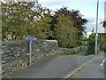
Cycle route sign, Main Street, Greenodd
The sign is for national cycle routes 70 (Barrow in Furness to Sunderland) and 700 (the Morecambe Bay Cycleway). They lead rather unpromisingly down a back alley, but after a few twists and turns eventually pick up the former Furness railway route towards Newby Bridge.
Image: © Stephen Craven
Taken: 11 Oct 2020
0.02 miles
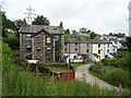
2
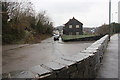
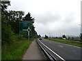
Greenodd village from the A590
The new dual carriageway has no connection into this village street.
Image: © Peter Turner
Taken: 10 Feb 2013
0.02 miles
3
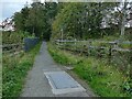
Path towards the estuary in Greenodd
This forms part of national cycle routes 70 and 700. There appears to be some significant utility infrastructure - probably water mains - beneath the path.
Image: © Stephen Craven
Taken: 11 Oct 2020
0.03 miles
4
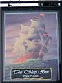
Sign for the Ship Inn
A sign focusing on the sea and seamen.
Image: © Maigheach-gheal
Taken: 25 Mar 2010
0.03 miles
5
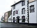
The Ship Inn, Greenodd
The Ship Inn is a traditional village pub on Main Street.
Image: © Maigheach-gheal
Taken: 25 Mar 2010
0.03 miles
6
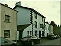
The Ship Inn, Main Street, Greenodd
According to a local shopkeeper, the Ship closed with the Covid-19 lockdown of March 2020 and as of October had not yet reopened, although there were signs of decorators having been at work inside.
The two houses beyond the pub in this photo are the only listed buildings in the village (grade II, list entry 1154862). The 1913 map labels one or both of these as PO (post office?).
Image: © Stephen Craven
Taken: 11 Oct 2020
0.03 miles
8
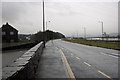
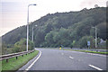
The A590 at Greenodd
Looking north with the Leven estuary with footbridge to the right beyond the dual carriageway.
Image: © Peter Turner
Taken: 10 Feb 2013
0.04 miles
9
A590, Greenodd
The main road now by-passes the village.
Image: © JThomas
Taken: 2 Jul 2021
0.04 miles
10
Greenodd : A590
Looking along the A590.
Image: © Lewis Clarke
Taken: 24 Sep 2019
0.04 miles