IMAGES TAKEN NEAR TO
Horseshoe Drive, LIVERPOOL, L10 4UF
Introduction
This page details the photographs taken nearby to Horseshoe Drive, L10 4UF by members of the Geograph project.
The Geograph project started in 2005 with the aim of publishing, organising and preserving representative images for every square kilometre of Great Britain, Ireland and the Isle of Man.

There are currently over 7.5m images from over14,400 individuals and you can help contribute to the project by visiting https://www.geograph.org.uk
Image Map
Images are licensed for reuse under creativecommons.org/licenses/by-sa/2.0
Notes
- Clicking on the map will re-center to the selected point.
- The higher the marker number, the further away the image location is from the centre of the postcode.
Image Listing (10 Images Found)
Images are licensed for reuse under creativecommons.org/licenses/by-sa/2.0
Image
Details
Distance
1
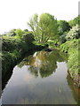
River Alt, Fazakerley
Looking south along the River Alt from the modern bridge that carries Valley Road.
Image: © John S Turner
Taken: 16 May 2014
0.16 miles
2
Bridge over the River Alt, Fazakerley
Looking across the River Alt towards the entrance to Lime Tree Woods. The A506 Valley Road is out of sight on the right.
Image: © John S Turner
Taken: 16 May 2014
0.17 miles
3
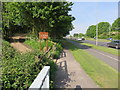
Entrance to Lime Tree Woods
The entrance to Lime Tree Woods alongside the A506 Valley Road. The River Alt flows below the road at this point.
Image: © John S Turner
Taken: 16 May 2014
0.17 miles
4
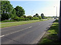
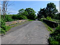
Valley Road, Fazakerley
Looking ENE along the A506 Valley Road.
Image: © John S Turner
Taken: 16 May 2014
0.19 miles
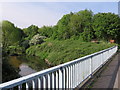
5
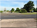
Two bridges over the River Alt, Fazakerley
Looking across the A506 dual carriageway, Valley Road, towards the much older sandstone Alder's Bridge. Both bridges are over the River Alt. Old maps up to 1891 show the road as Ingoe Lane, which then becomes Moor Lane on the 1908 map. By 1974 the lane had become a dual carriageway and the name was changed to Valley Road. The modern maps still show Alder's Bridge as carrying the cut off Moor Lane.
Image: © John S Turner
Taken: 16 May 2014
0.20 miles
6
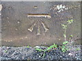
Bench mark on Alder's Bridge, Fazakerley
Ordnance Survey bench mark near the south east corner of Alder's Bridge. Maps up to 1937 show a bench mark at the centre of the north parapet opposite, but that stonework is very weathered so I presume that mark has been lost to erosion.
Image: © John S Turner
Taken: 16 May 2014
0.21 miles
7
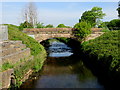
Alder's Bridge over the River Alt
Looking towards Alder's Bridge from the modern bridge that carries the A506 dual carriageway. The historic Alder's Bridge carries what is left of the by-passed Moor Lane over the River Alt.
Image: © John S Turner
Taken: 16 May 2014
0.21 miles
8
Alder's Bridge over the River Alt
Looking along the by-passed Moor Lane where it crosses Alder's Bridge over the River Alt. There is an Ordnance Survey bench mark at the far end of the bridge on the right hand parapet. See Image
Image: © John S Turner
Taken: 16 May 2014
0.22 miles