IMAGES TAKEN NEAR TO
Carnarc Crescent, INVERNESS, IV3 8SJ
Introduction
This page details the photographs taken nearby to Carnarc Crescent, IV3 8SJ by members of the Geograph project.
The Geograph project started in 2005 with the aim of publishing, organising and preserving representative images for every square kilometre of Great Britain, Ireland and the Isle of Man.

There are currently over 7.5m images from over14,400 individuals and you can help contribute to the project by visiting https://www.geograph.org.uk
Image Map
Images are licensed for reuse under creativecommons.org/licenses/by-sa/2.0
Notes
- Clicking on the map will re-center to the selected point.
- The higher the marker number, the further away the image location is from the centre of the postcode.
Image Listing (72 Images Found)
Images are licensed for reuse under creativecommons.org/licenses/by-sa/2.0
Image
Details
Distance
1
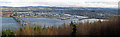
Inverness from the viewpoint on Ord Hill
There is a way marked path on Ord Hill to a good viewpoint over the Kessock Bridge and Inverness beyond. The River Ness enters the Moray Firth directly opposite the viewpoint. Hills block the southern expansion of the city and form sides to the valley occupied by Loch Ness.
This image is a stitch of three images and is available as a panorama 1050 pixels wide.
Image: © Julian Paren
Taken: 7 Mar 2015
0.04 miles
2
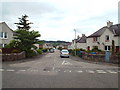
Craigton Avenue, Inverness
Craigton Avenue in South Kessock, Inverness.
Image: © Malc McDonald
Taken: 22 Jun 2015
0.10 miles
3
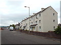
Flats on Kessock Road, Inverness
Low-rise flats on Kessock Road, in Inverness.
Image: © Malc McDonald
Taken: 22 Jun 2015
0.11 miles
4
South Kessock Shore, Carnac Point and Kessock Bridge
Carnac Point is at South Kessock, Inverness. A small navigation beacon tower is situated on the point, which extends out into the Beauly Firth. Part of the Kessock Bridge can be seen behind the tower.
Image: © David Dixon
Taken: 4 Apr 2017
0.12 miles
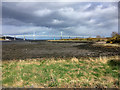
5
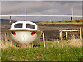
Sewage pumping station, South Kessock
Image: © Bill Harrison
Taken: 12 Apr 2024
0.13 miles
6
Parking area, Kessock Road
The houses here have an open view over the mouth of the River Ness.
The red square slab in the foreground is engraved with 'When the clouds are gloomy my eyes are blue'.
Image: © Richard Dorrell
Taken: 6 Mar 2019
0.14 miles
7
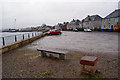
River Ness Estuary
The mouth of the River Ness at South Kessock.
The River Ness (Scottish Gaelic: Abhainn Nis) is a relatively short river about 12 miles long which flows from the northern end of Loch Ness, through Loch Dochfour, to Inverness, where it discharges into the Beauly Firth. The river is the origin of the name of the city of Inverness which is from the Scottish Gaelic: Inbhir Nis, meaning "Mouth of the Ness".
Image: © David Dixon
Taken: 4 Apr 2017
0.14 miles
8
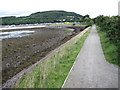
Seawall path in Merkinch Local Nature Reserve
See www.merkinchlnr.org.uk
Image: © Chris Wimbush
Taken: 17 Jul 2010
0.15 miles
9

Tangle Tower, South Kessock
Now a residence but previously a coastguard station and the base of the 3 coastguards lost in the 1894 South Kessock ferry tragedy. See Image
Image: © John Lucas
Taken: 12 Apr 2018
0.15 miles
10
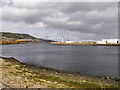
Beauly Firth and Kessock Bridge
The Kessock Bridge (Gaelic: Drochaid Cheasaig) is a cable stayed bridge which carries the A9 trunk road across the Beauly Firth, an inlet of the Moray Firth, between Inverness and the village of North Kessock.
The bridge has a total length of 1,056 metres with a main span of 240 metres. It is raised high over sea level because the Beauly Firth is a navigable waterway. The four bridge towers dominate the Inverness skyline, especially at night when they are lit. Construction on the bridge began in 1976, with completion and opening in 1982. Prior to 1982, travellers north of Inverness had the choice of the Kessock Ferry or a journey via Beauly.
Image: © David Dixon
Taken: 4 Apr 2017
0.15 miles