Inverness from the viewpoint on Ord Hill
Introduction
The photograph on this page of Inverness from the viewpoint on Ord Hill by Julian Paren as part of the Geograph project.
The Geograph project started in 2005 with the aim of publishing, organising and preserving representative images for every square kilometre of Great Britain, Ireland and the Isle of Man.

There are currently over 7.5m images from over 14,400 individuals and you can help contribute to the project by visiting https://www.geograph.org.uk
Inverness from the viewpoint on Ord Hill
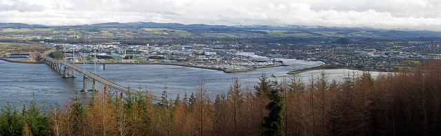
Image: © Julian Paren Taken: 7 Mar 2015
There is a way marked path on Ord Hill to a good viewpoint over the Kessock Bridge and Inverness beyond. The River Ness enters the Moray Firth directly opposite the viewpoint. Hills block the southern expansion of the city and form sides to the valley occupied by Loch Ness. This image is a stitch of three images and is available as a panorama 1050 pixels wide.
Images are licensed for reuse under creativecommons.org/licenses/by-sa/2.0
Image Location
Latitude
57.492454
Longitude
-4.241781