IMAGES TAKEN NEAR TO
Gibson Gardens, STORNOWAY, HS1 2AG
Introduction
This page details the photographs taken nearby to Gibson Gardens, HS1 2AG by members of the Geograph project.
The Geograph project started in 2005 with the aim of publishing, organising and preserving representative images for every square kilometre of Great Britain, Ireland and the Isle of Man.

There are currently over 7.5m images from over14,400 individuals and you can help contribute to the project by visiting https://www.geograph.org.uk
Image Map (Loading...)


Getting Data...Please wait
Leaflet Map data © OpenStreetMap
Images are licensed for reuse under creativecommons.org/licenses/by-sa/2.0
Notes
- Clicking on the map will re-center to the selected point.
- The higher the marker number, the further away the image location is from the centre of the postcode.
Image Listing (35 Images Found)
Images are licensed for reuse under creativecommons.org/licenses/by-sa/2.0
Image
Details
Distance
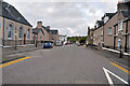
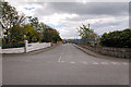
1
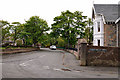
Goathill Crescent
The small road in view is part of Goathill Crescent which also runs from my left around and behind to the right joining at the roundabout on Leverhulme Drive.
Image: © Stephen Branley
Taken: 19 May 2009
0.06 miles
2
Plantation Road
This quiet road runs from Scotland Street to Mackenzie Street.
Image: © Stephen Branley
Taken: 19 May 2009
0.11 miles
3
Leverhulme Drive
Named after Lord Leverhulme, who bought the island in 1918, it looks out onto the Lewis & Harris War Memorial.
Image: © Stephen Branley
Taken: 17 Nov 2007
0.11 miles
4
Goathill Road
Goathill Road, the Beverley Hills of Stornoway, runs off Matheson Road, behind me, for nearly half a mile up to Anderson road. The first junction on the left is Goathill Crescent.
Image: © Stephen Branley
Taken: 19 May 2009
0.11 miles
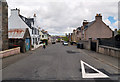
5
Scotland Street
Scotland Street as viewed from the junction of Matheson Road, with the Free Presbyterian Church on the left
Image: © Stephen Branley
Taken: 19 May 2009
0.13 miles
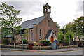
6
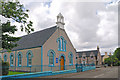
Free Presbyterian Church
This church sits on the corner of Matheson Road and behind it, Scotland Street. At this time they're repainting the railings and the wall to black, whether the window frames will follow remains to be seen.
Image: © Stephen Branley
Taken: 12 Aug 2008
0.13 miles
7
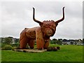
Highland Cow, Stornoway
I could safely approach this Highland cow on a patch of grass in Stornoway.
Image: © Rude Health
Taken: 21 Sep 2013
0.15 miles
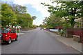
8
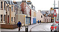
Bayhead Street
Bayhead looking towards Cromwell Street on yet another wet day in Stornoway.
Image: © Stephen Branley
Taken: 9 Mar 2009
0.16 miles
9
Smith Avenue
Smith Avenue runs off Goathill Road down to Sandwick Road. The Nicolson Institute artificial playing surface is behind the bush on the right.
Image: © Stephen Branley
Taken: 19 May 2009
0.16 miles
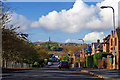
10
Stornoway High Church
As churches go here on the island this is one of the better looking ones mainly owing to the fine bell tower. Known as the United Free High Church it's celebrating its centenary as the ministry took possession of the church building in July 1909. It sits at the junction of Matheson Road and Goathill Road and is viewed from the junction of Matheson Road and Church Street.
Image: © Stephen Branley
Taken: 19 May 2009
0.16 miles