IMAGES TAKEN NEAR TO
Hoovers Lane, ROSS-ON-WYE, HR9 5TU
Introduction
This page details the photographs taken nearby to HR9 5TU by members of the Geograph project.
The Geograph project started in 2005 with the aim of publishing, organising and preserving representative images for every square kilometre of Great Britain, Ireland and the Isle of Man.

There are currently over 7.5m images from over14,400 individuals and you can help contribute to the project by visiting https://www.geograph.org.uk
Image Map
Images are licensed for reuse under creativecommons.org/licenses/by-sa/2.0
Notes
- Clicking on the map will re-center to the selected point.
- The higher the marker number, the further away the image location is from the centre of the postcode.
Image Listing (19 Images Found)
Images are licensed for reuse under creativecommons.org/licenses/by-sa/2.0
Image
Details
Distance
1
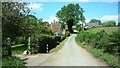
Road towards Pontshill
Looking towards Newhouse Farm
Image: © Clint Mann
Taken: 6 Sep 2015
0.04 miles
2
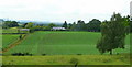
View to Lea Bailey
Looking south-west from Hoovers Lane near Newhouse Farm.
Image: © Jonathan Billinger
Taken: 11 Jul 2008
0.09 miles
3
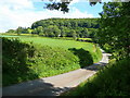
Hoovers Lane
Approaching Lea Bailey Lane from the north-west. The wooded hill of East Dean is one of the northernmost outposts of the Forest of Dean.
Image: © Jonathan Billinger
Taken: 11 Jul 2008
0.10 miles
4
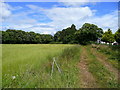
Track and footpath
Leading east to The Lea from Hoovers Lane near Newhouse Farm.
Image: © Jonathan Billinger
Taken: 11 Jul 2008
0.10 miles
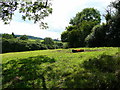
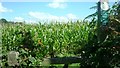
5
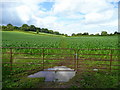
Maize crop
The grassy area in the foreground is the trackbed of a dismantled railway, and the farm just visible in the middle distance left is Newhouse Farm.
Image: © Jonathan Billinger
Taken: 11 Jul 2008
0.12 miles
6
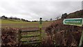
Footpath realignment
From the impassible stile at Image, a few yards up the road, the walkers of South Herefordshire now use this gate to walk the mile or so of public footpath to Lea.
Image: © Jonathan Billinger
Taken: 11 Jul 2008
0.13 miles
7
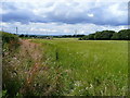
Grass ready for cutting
Some fine hay to be made here soon. View north west from Hoovers Lane.
Image: © Jonathan Billinger
Taken: 11 Jul 2008
0.14 miles
8
Footpath across a cultivated field
This would make very heavy muddy walking at this time of the year.
Image: © Jonathan Billinger
Taken: 19 Dec 2019
0.14 miles
9
Obstructed footpath
Walkers following the Explorer OS Map may find the footpath marked in green on the map is not walkable owing to the planting of a field of tall maize. There is a route to the north of this area where a narrow passageway has been left between the stems; this is evidenced by the black lines that can be found on larger scale versions of the map.
Image: © Clint Mann
Taken: 6 Sep 2015
0.15 miles
10
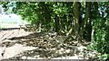
Path, mud and railway cutting edge
This muddy public footpath is viewed at a junction where the path has just turned to run parallel with the deep cutting (to right and below in image) that represents the remains of a dismantled railway line. Remnants of carts, wheels etc are in evidence on the ground here.
Image: © Clint Mann
Taken: 6 Sep 2015
0.17 miles