IMAGES TAKEN NEAR TO
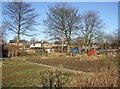
Ward Court, BRIGHOUSE, HD6 3UZ
Introduction
This page details the photographs taken nearby to Ward Court, HD6 3UZ by members of the Geograph project.
The Geograph project started in 2005 with the aim of publishing, organising and preserving representative images for every square kilometre of Great Britain, Ireland and the Isle of Man.

There are currently over 7.5m images from over14,400 individuals and you can help contribute to the project by visiting https://www.geograph.org.uk
Image Map
Images are licensed for reuse under creativecommons.org/licenses/by-sa/2.0
Notes
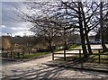
- Clicking on the map will re-center to the selected point.
- The higher the marker number, the further away the image location is from the centre of the postcode.
Image Listing (244 Images Found)
Images are licensed for reuse under creativecommons.org/licenses/by-sa/2.0
Image
Details
Distance
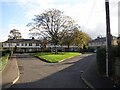
1
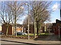
Council housing, Chapel Croft, Rastrick (SE 138 213)
This is a very pleasant council estate, with houses grouped around areas of grass and trees, and an open area of playing fields behind.
Image: © Humphrey Bolton
Taken: 2 Mar 2006
0.01 miles
2
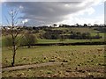
Rough pasture behind Chapel Croft, Rastrick
This is a former stone mine, but the strip of concrete was used for cricket practice by the boys of Rastrick Grammar School, Ogden Lane. Nets were erected round the strip for batting and bowling practice, the entire field being used for sports by the school at that time until the school's amalgamation with Reinswood School to form Rastrick High in approx. 1983. Most of the mined area has been turned into the playing fields in the middle distance, and Toothill is at the top of the far hillside.
Image: © Humphrey Bolton
Taken: 2 Mar 2006
0.06 miles
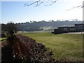
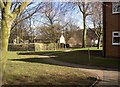
3
Carr Green Junior, Infant & Nursery School
View of the school and playing fields from Toothill Bank.
http://www.carrgreenschool.org.uk/
Image: © Tim Marchant
Taken: 21 Oct 2008
0.06 miles
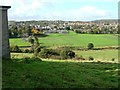
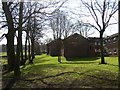
4
The back of Carr Green Lane School, Rastrick (SE138 212)
The hedge separates the school grounds from Ward Court, off Chapel Croft. In the distance there is a large area of playing fields, then the hillside up to Toothill.
Image: © Humphrey Bolton
Taken: 3 Mar 2006
0.06 miles
5
Crowtrees Crescent, Rastrick
Crowtrees Crescent was built as a council housing estate - one of the first in Brighouse. There were 20 houses and 2 bungalows, but there had been a quarry in the site and four of the houses subsided and collapsed.
Image: © Humphrey Bolton
Taken: 12 Nov 2005
0.06 miles
6
Footpath from Chapel Croft to Ogden Lane, Rastrick (SE 138 214)
This is not a public footpath, but has been made to provide a short-cut from the end of the cul-de-sac to Ogden Lane.
Image: © Humphrey Bolton
Taken: 2 Mar 2006
0.06 miles
7
The back of Chapel Croft housing estate, Rastrick (SE138 214)
No gardening to do (apart from in the allotments up the road), and surrounded by grass and trees.
Image: © Humphrey Bolton
Taken: 2 Mar 2006
0.06 miles
8
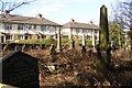
The neglected far end of Rastrick Churchyard (SE138 214)
This is looking over the wall next to the footpath from the end of Chapel Croft. The houses are in Crowtrees Crescent.
Image: © Humphrey Bolton
Taken: 2 Mar 2006
0.06 miles
9
Entrance to Rastrick Health Centre (SE 137 213)
Chapel Croft is a cul-de-sac off Crowtrees Lane (A643) and the first building on the right is the Health Centre. Next to it are some allotments, then the road turns left and runs parallel to the main road.
Image: © Humphrey Bolton
Taken: 2 Mar 2006
0.07 miles
10
Allotments and Health Centre off Chapel Croft, Rastrick (SE 137 213)
A concrete track runs alongside the allotments, giving access via a gate. From here the Health Centre, a flat-roofed building typical of the 1960s to 80s, can be seen, with houses fronting onto Crowtrees Lane beyond.
Image: © Humphrey Bolton
Taken: 3 Mar 2006
0.07 miles