IMAGES TAKEN NEAR TO
Lockwood Scar, HUDDERSFIELD, HD4 6BP
Introduction
This page details the photographs taken nearby to Lockwood Scar, HD4 6BP by members of the Geograph project.
The Geograph project started in 2005 with the aim of publishing, organising and preserving representative images for every square kilometre of Great Britain, Ireland and the Isle of Man.

There are currently over 7.5m images from over14,400 individuals and you can help contribute to the project by visiting https://www.geograph.org.uk
Image Map
Images are licensed for reuse under creativecommons.org/licenses/by-sa/2.0
Notes
- Clicking on the map will re-center to the selected point.
- The higher the marker number, the further away the image location is from the centre of the postcode.
Image Listing (211 Images Found)
Images are licensed for reuse under creativecommons.org/licenses/by-sa/2.0
Image
Details
Distance
1
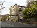
Sovereign Court, Lockwood Scar
Converted into flats.
Image: © JThomas
Taken: 8 Nov 2018
0.01 miles
2
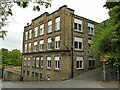
Former Scarr Mill, Lockwood Scar
A former woollen mill, now converted to apartments and known as Sovereign Court. The road to the right is Enoch Lane.
Image: © Stephen Craven
Taken: 25 Sep 2022
0.01 miles
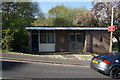
3
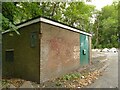
Electrical substation, Coal Pit Lane, Lockwood
Image: © Stephen Craven
Taken: 25 Sep 2022
0.03 miles
4
Coal Pit Lane, Salford, Almondbury
This narrow lane runs between Lockwood Scar and Whitehead Lane. The pit seems to have been Woodton Coal Pit on the top side of Whitehead Lane. There was also a sandstone quarry there.
Image: © Humphrey Bolton
Taken: 15 Jun 2006
0.03 miles
5
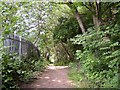
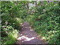
Footpath at Wood End, Salford, Almondbury
This footpath runs past Broadfield Mills and along the river bank towards Huddersfield.
Image: © Humphrey Bolton
Taken: 15 Jun 2006
0.03 miles
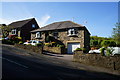
9
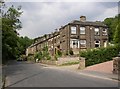
Terrace houses along Whitehead Lane at Scar End, Almondbury
The builder squeezed an extra house into the site by making two houses back onto the side of the last through terrace house. The one on the left shows a feature often seen - 'blind' windows which were probably originally built with stone infill rather than glass.
Image: © Humphrey Bolton
Taken: 15 Jun 2006
0.04 miles
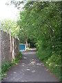
10
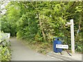
Wood End, Lockwood
A sign indicates the start of an 800m walking and cycling route known as Riverside Way, towards Huddersfield town centre.
Image: © Stephen Craven
Taken: 25 Sep 2022
0.05 miles