IMAGES TAKEN NEAR TO
Newton Road, WEMBLEY, HA0 4EU
Introduction
This page details the photographs taken nearby to Newton Road, HA0 4EU by members of the Geograph project.
The Geograph project started in 2005 with the aim of publishing, organising and preserving representative images for every square kilometre of Great Britain, Ireland and the Isle of Man.

There are currently over 7.5m images from over14,400 individuals and you can help contribute to the project by visiting https://www.geograph.org.uk
Image Map
Images are licensed for reuse under creativecommons.org/licenses/by-sa/2.0
Notes
- Clicking on the map will re-center to the selected point.
- The higher the marker number, the further away the image location is from the centre of the postcode.
Image Listing (32 Images Found)
Images are licensed for reuse under creativecommons.org/licenses/by-sa/2.0
Image
Details
Distance
1
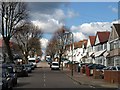
Lyon Park Avenue, Alperton
A residential road climbing away from Heather Park.
Image: © Derek Harper
Taken: 19 Mar 2012
0.14 miles
2
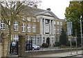
Alperton Community School Upper School
This building housed the grammar school, Wembley County School, which in 1967 was amalgamated with other schools in the area to form the comprehensive school called Alperton High School.
Image: © Rod Allday
Taken: 16 Oct 2015
0.15 miles
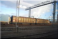
4

Main Line
Main railway line heading to Brent Junction by allotments behind the houses on Lyon Park Avenue
Image: © Shaun Ferguson
Taken: 27 Mar 2009
0.17 miles
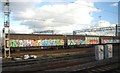
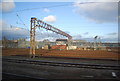
7

West Coast Main Line and sidings, Wembley
Image: © N Chadwick
Taken: 19 Dec 2010
0.18 miles
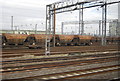
8
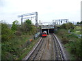
A Bakerloo line train passes under the West Coast Main Line
The London & Birmingham Railway opened from Euston to Boxmoor in 1837, and on to Birmingham in 1838. In 1846 it became part of the London & North Western Railway. Suburban services were diverted in 1912 to run over the "New Lines", which had just been built: these follow the route used today by Bakerloo line trains. The latter first operated over this section in 1917.
Apart from the West Coast Main Line and the local line operated by London Overground and the Bakerloo line, there is a huge area of sidings extending for two miles, from Harlesden almost to Wembley Central. At their widest these are 350 metres across. Passengers on Bakerloo or London Overground trains at first follow the northern edge of the complex through Stonebridge Park station. Just before Wembley Central, the Bakerloo and Overground pass under the main line to emerge on its southern edge.
This is the view from the long footbridge between Lyon Park Avenue and London Road, just to the south of Wembley Central station, looking in the direction of Stonebridge Park. A Bakerloo train heading towards Elephant & Castle is about to pass under the main lines and sidings. For the view looking in the other direction see http://www.geograph.org.uk/photo/4216433
Image: © Marathon
Taken: 22 Oct 2014
0.18 miles
9
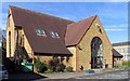
St James Church Centre, Stanley Avenue, Alperton, HA0 4JB
Image: © John Salmon
Taken: 7 Mar 2008
0.18 miles