IMAGES TAKEN NEAR TO
Shelley Gardens, WEMBLEY, HA0 3QG
Introduction
This page details the photographs taken nearby to Shelley Gardens, HA0 3QG by members of the Geograph project.
The Geograph project started in 2005 with the aim of publishing, organising and preserving representative images for every square kilometre of Great Britain, Ireland and the Isle of Man.

There are currently over 7.5m images from over14,400 individuals and you can help contribute to the project by visiting https://www.geograph.org.uk
Image Map
Images are licensed for reuse under creativecommons.org/licenses/by-sa/2.0
Notes
- Clicking on the map will re-center to the selected point.
- The higher the marker number, the further away the image location is from the centre of the postcode.
Image Listing (24 Images Found)
Images are licensed for reuse under creativecommons.org/licenses/by-sa/2.0
Image
Details
Distance
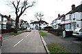
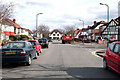
1
South Kenton: Carlton Avenue West
Looking west from the Nathans Road junction. At its far end, Carlton Avenue West makes a junction with Watford Road, (A404).
Image: © Dr Neil Clifton
Taken: 4 Mar 2010
0.13 miles
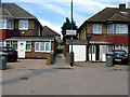
2
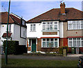
South Kenton: 22 Carlton Avenue West
This semi-detached house on the Sudbury Court estate was bought when new in 1930 and has remained in the same family ownership since then.
Image: © Dr Neil Clifton
Taken: 8 Mar 2010
0.13 miles
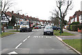
3
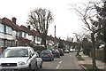
South Kenton: Langham Gardens
Looking south from the junction with Carlton Avenue West, a pair of 'semis' can be seen (far left) which still exemplify the full Mock Tudor style, as when they were built on the 1930s. At this point there is a sharp right hand bend in Langham Gardens, which then forms a T-junction with Oldborough Road.
Image: © Dr Neil Clifton
Taken: 4 Mar 2010
0.13 miles
4
North Wembley: Passage leading north from Byron Road
This pedestrian way gives access into Nathans Road
Image: © Dr Neil Clifton
Taken: 1 Jun 2011
0.13 miles
5
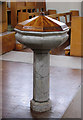
The Annunciation, Windermere Avenue, London HA3 - Font
Image: © John Salmon
Taken: 16 Feb 2005
0.14 miles
6
South Kenton: Carlton Avenue West
Looking east, towards the T-junction with Nathans Road. On the right nearer the camera is the end of Langham Gardens.
Image: © Dr Neil Clifton
Taken: 4 Mar 2010
0.17 miles
7
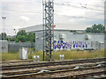
London Borough of Brent : West Coast Main Line
Looking across and along the West Coast Main Line from the Bakerloo Line.
Image: © Lewis Clarke
Taken: 18 Jul 2019
0.17 miles
8
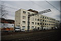
Wembley High Technology College
The trees screening this view until recently seem to have been removed, and the next one along does not look too healthy.
Image: © Robin Webster
Taken: 29 Sep 2012
0.18 miles
9
South Kenton: Abbott's Drive
Looking west from its junction with Nathans Road, Abbotts Drive curves round gently and forms a T-junction with Norval Road at its far end.
Image: © Dr Neil Clifton
Taken: 4 Mar 2010
0.19 miles