IMAGES TAKEN NEAR TO
Northchapel, PETWORTH, GU28 9LB
Introduction
This page details the photographs taken nearby to GU28 9LB by members of the Geograph project.
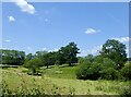
The Geograph project started in 2005 with the aim of publishing, organising and preserving representative images for every square kilometre of Great Britain, Ireland and the Isle of Man.

There are currently over 7.5m images from over14,400 individuals and you can help contribute to the project by visiting https://www.geograph.org.uk
Image Map
Images are licensed for reuse under creativecommons.org/licenses/by-sa/2.0
Notes
- Clicking on the map will re-center to the selected point.
- The higher the marker number, the further away the image location is from the centre of the postcode.
Image Listing (29 Images Found)
Images are licensed for reuse under creativecommons.org/licenses/by-sa/2.0
Image
Details
Distance
1
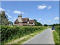
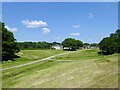
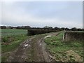
Mitchell Park Farm Cottages, Pipers Lane
Not marked on Northchapel's 1837 tithe map but do appear on an OS map surveyed in the 1870s. Mitchell park Farm can be seen in the distance.
Image: © Simon Carey
Taken: 2 Jun 2024
0.01 miles
2
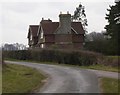
House on Pipers Lane near Northchapel
The road off to the right is the private track to Mitchell Park Farm.
Image: © Shazz
Taken: 12 Mar 2010
0.03 miles
3
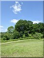
Pond Bay, Mitchell Park Forge
The bay was constructed for a pen pond, see Image, for the forge, see Image Pen ponds were extra reservoirs of water released to fill the main pond when water was running low. There is another, see Image, a little downstream. Much of the bay's remains is amongst the foliage with just small rises on the ground indicating its former presence.
Image: © Simon Carey
Taken: 2 Jun 2024
0.05 miles
4
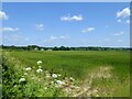
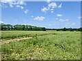
Brick Kiln Field
The name of the field according to Northchapel's 1837 tithe map bounded to the west and north by Pipers Lane. In the distance to the left is Image
Image: © Simon Carey
Taken: 2 Jun 2024
0.06 miles
5
Site of Old Pond Copse
The name of the field according to Northchapel's 1837 tithe map that was originally the site of a pen pond for Image Located on the western side of Image with Image, another former pen pond a little downstream. Pen ponds were extra reservoirs of water used to replenish the main hammer pond when water ran low in it. By the 1830s this was a small copse which had been grubbed when the OS surveyed in the 1870s.
Image: © Simon Carey
Taken: 2 Jun 2024
0.06 miles
6
Upper Ash Croft/Middle Ash Croft/Further Ash Croft
The name of the fields according to Northchapel's 1837 tithe map that have been merged. Upper Ash Croft was to the south bounded by pipers Lane on its southern and eastern side, Further Ash Croft was to the north and is next to Image, whilst Middle Ash Croft was, surprisingly, between the two.
Image: © Simon Carey
Taken: 2 Jun 2024
0.10 miles
7
Limekiln Patch
The name of the field according to Northchapel's 1837 tithe map with Mitchell Park Farm to the north. The former limekiln was located on the right between the track and the pond.
Image: © Simon Carey
Taken: 2 Jun 2024
0.10 miles
8
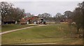
Mitchell Park Farm on Pipers Lane near Northchapel
There are many geese here attracted to the large pond.
Image: © Shazz
Taken: 12 Mar 2010
0.13 miles
9
Four-way Junction
A crossing path provides a four-way option at the junction of fields just ahead. The footpath maker was not in good condition with only one of the four fingers on the post still in place.
Image: © Chris Thomas-Atkin
Taken: 30 Dec 2018
0.17 miles
10
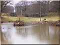
Pond at Mitchell Park Farm
The next grid square to the west starts in the centre of the pond.
Image: © Shazz
Taken: 12 Mar 2010
0.17 miles