IMAGES TAKEN NEAR TO
Forty Green, Lowbands, GLOUCESTER, GL19 3SL
Introduction
This page details the photographs taken nearby to Forty Green, Lowbands, GL19 3SL by members of the Geograph project.
The Geograph project started in 2005 with the aim of publishing, organising and preserving representative images for every square kilometre of Great Britain, Ireland and the Isle of Man.

There are currently over 7.5m images from over14,400 individuals and you can help contribute to the project by visiting https://www.geograph.org.uk
Image Map
Images are licensed for reuse under creativecommons.org/licenses/by-sa/2.0
Notes
- Clicking on the map will re-center to the selected point.
- The higher the marker number, the further away the image location is from the centre of the postcode.
Image Listing (17 Images Found)
Images are licensed for reuse under creativecommons.org/licenses/by-sa/2.0
Image
Details
Distance
1
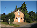
Chapel House, Lowbands
Lowbands is a former Chartist settlement, now designated as a Conservation Area. In the mid 1840s the Chartist Movement attempted to settle “the working classes" on the land. Around forty houses were built in the settlement which has few facilities or services. The houses which are left are distinctive in that they are set in spacious grounds of between one and five acres. Much of the original layout remains filling most of the grid square.
Image: © Pauline E
Taken: 29 Sep 2008
0.02 miles
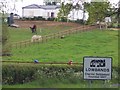
2
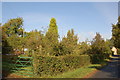
Orchard at Lowbands
An old apple and pear orchard growing in the Chartist settlement of Lowbands. Lowbands was the second Chartist estate created in 1846. Rows of fruit trees were provided for the 23 smallholders along with 22 working horses, firewood, manure and seeds.The estate was sold off in 1851 when the Chartist Land Company was declared illegal by a House of Commons Select Committee.
Image: © Roger Davies
Taken: 10 Oct 2009
0.02 miles
3
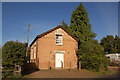
Chapel House (formerly the Bible Christian Chapel) Lowbands
The chapel was built in 1858 to serve a secular community created originally by the Chartist Land Company in 1846. The 23 smallholdings had been sold off in 1851 when the land company was declared illegal.
Image: © Roger Davies
Taken: 10 Oct 2009
0.06 miles
4
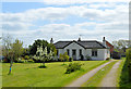
Chartist bungalow, Lowbands
In fine, original condition, this delightful house dates from 1847 when Feargus O'Connor founded his ill-fated Chartist Co-operative community here.
Image: © Philip Pankhurst
Taken: 13 Apr 2014
0.09 miles
5
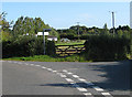
Road junction, Lowbands
Right to Gadfield Elm and Staunton, left to Playley Green and Redmarley D'Abitot. Lowbands is a former Chartist settlement, now designated as a Conservation Area. In the mid 1840s the Chartist Movement attempted to settle “the working classes" on the land. Around forty houses were built in the settlement which has few facilities or services. The houses which are left are distinctive in that they are set in spacious grounds of between one and five acres. Much of the original layout remains filling most of the grid square.
Image: © Pauline E
Taken: 29 Sep 2008
0.10 miles
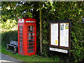
6
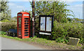
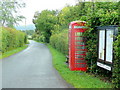
Village centrepiece, Lowbands
K6 telephone box, village notice board, a bench for the weary and a reminder in stone of the origins of this idyllic little community in the centre of Lowbands.
Image: © Philip Pankhurst
Taken: 13 Apr 2014
0.12 miles
7
Phone box at Lowlands, former Chartist settlement
Lowbands is a former Chartist settlement, now designated as a Conservation Area. In the mid 1840s the Chartist Movement attempted to settle “the working classes" on the land. Around forty houses were built in the settlement which has few facilities or services. The houses which are left are distinctive in that they are set in spacious grounds of between one and five acres. Much of the original layout remains filling most of the grid square.
Image: © Pauline E
Taken: 29 Sep 2008
0.13 miles
8
Lowbands
The Chartist, or National, Land Company was founded in 1845 to establish families from the factory towns on smallholdings, where they could maintain themselves and qualify for a vote.
Image: © Bob Embleton
Taken: 3 May 2005
0.13 miles
9
Chartist Lane, Lowbands
Phone box, notice board and bench within this rural community.
Image: © Jonathan Billinger
Taken: 22 Jun 2011
0.13 miles
10
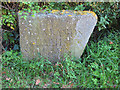
Commemorative stone, Chartist settlement 1847
Lowbands is a former Chartist settlement, now designated as a Conservation Area. In the mid 1840s the Chartist Movement attempted to settle “the working classes" on the land. Around forty houses were built in the settlement which has few facilities or services. The houses which are left are distinctive in that they are set in spacious grounds of between one and five acres. Much of the original layout remains filling most of the grid square.
Image: © Pauline E
Taken: 29 Sep 2008
0.13 miles