IMAGES TAKEN NEAR TO
Taffern Bach, WOTTON-UNDER-EDGE, GL12 8LQ
Introduction
This page details the photographs taken nearby to Taffern Bach, GL12 8LQ by members of the Geograph project.
The Geograph project started in 2005 with the aim of publishing, organising and preserving representative images for every square kilometre of Great Britain, Ireland and the Isle of Man.

There are currently over 7.5m images from over14,400 individuals and you can help contribute to the project by visiting https://www.geograph.org.uk
Image Map
Images are licensed for reuse under creativecommons.org/licenses/by-sa/2.0
Notes
- Clicking on the map will re-center to the selected point.
- The higher the marker number, the further away the image location is from the centre of the postcode.
Image Listing (31 Images Found)
Images are licensed for reuse under creativecommons.org/licenses/by-sa/2.0
Image
Details
Distance
1
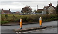
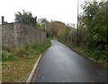
Tafarn Bach houses, Charfield Hill
Viewed across the B4509. Why does this part of South Gloucestershire, England have a Welsh name?
Image: © Jaggery
Taken: 28 Oct 2012
0.05 miles
2
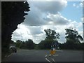
Roundabout at Charfield Hill
The junction of B4509 and B4058
Image: © David Smith
Taken: 28 Jul 2012
0.06 miles
3
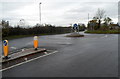
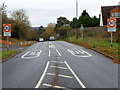
Recently-installed mini-roundabout, Charfield Hill
The mini-roundabout at crossroads at the top of Charfield Hill, seen here in late October 2012,
does not appear in a Google Earth Street View taken in June 2009.
Image: © Jaggery
Taken: 28 Oct 2012
0.06 miles
4
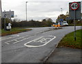
B4058 approaches crossroads at the top of Charfield Hill
Looking towards the mini-roundabout http://www.geograph.org.uk/photo/3728448 in the middle of the crossroads. The speed limit increases from 30mph to 40mph.
Image: © Jaggery
Taken: 28 Oct 2012
0.06 miles
5
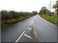
Charfield - please drive carefully
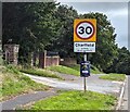
At the western edge of Charfield in South Gloucestershire, the 40mph speed limit drops to 30mph.
Image: © Jaggery
Taken: 30 Jul 2023
0.06 miles
6
Approaching crossroads on Charfield Hill
Viewed along the B4058 in the west of Charfield. The sign on the left shows turn left ahead for Churchend, right for Tortworth and Falfield or ahead for Cromhall and Wickwar.
Image: © Jaggery
Taken: 28 Oct 2012
0.06 miles
7
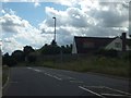
Charfield Hill
The B4058 drops towards Charfield with a scattering of houses on the hill
Image: © David Smith
Taken: 28 Jul 2012
0.07 miles
8
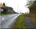
Western boundary of Charfield
The 40mph speed limit on the B4058 reduces to 30mph at the boundary sign for Charfield,
a village in South Gloucestershire near Wotton-under-Edge.
Image: © Jaggery
Taken: 28 Oct 2012
0.07 miles
9
Churchend Lane, Charfield
Churchend Lane heads SE away from Charfield Hill. Churchend is nearly a kilometre ahead.
Image: © Jaggery
Taken: 28 Oct 2012
0.09 miles
10
Road from Charfield to Yate and Chipping Sodbury
The B4058 heads away from Charfield Hill crossroads towards Yate and Chipping Sodbury via Cromhall and Wickwar.
Image: © Jaggery
Taken: 28 Oct 2012
0.10 miles