IMAGES TAKEN NEAR TO
Macleod Crescent, HELENSBURGH, G84 9QX
Introduction
This page details the photographs taken nearby to Macleod Crescent, G84 9QX by members of the Geograph project.
The Geograph project started in 2005 with the aim of publishing, organising and preserving representative images for every square kilometre of Great Britain, Ireland and the Isle of Man.

There are currently over 7.5m images from over14,400 individuals and you can help contribute to the project by visiting https://www.geograph.org.uk
Image Map
Images are licensed for reuse under creativecommons.org/licenses/by-sa/2.0
Notes
- Clicking on the map will re-center to the selected point.
- The higher the marker number, the further away the image location is from the centre of the postcode.
Image Listing (33 Images Found)
Images are licensed for reuse under creativecommons.org/licenses/by-sa/2.0
Image
Details
Distance
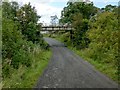
1
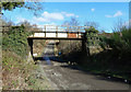
The West Highland Line
The track passing below the railway bridge is part of the local network of trails, which seem to be well-used.
Image: © Mary and Angus Hogg
Taken: 1 Mar 2013
0.04 miles
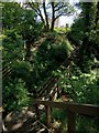
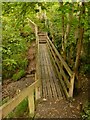
2
Leaving Duchess Wood
Here at the north-eastern corner of the woods, a path, by means of this wooden footbridge, leads down, across a burn, and then back up, to emerge from the woods at the point where MacLeod Crescent meets Paterson Drive.
For a view back across the bridge from the other side, see Image
Image: © Lairich Rig
Taken: 21 Apr 2016
0.05 miles
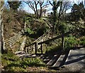
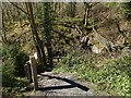
3
Footbridge in Duchess Wood
The bridge leads over a burn at the north-eastern extremity of the wood. On the other side of the bridge, the path ends at a Image
Image: © Lairich Rig
Taken: 14 Jul 2015
0.05 miles
4
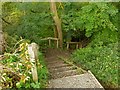
Entering Duchess Wood
At this point, a footpath through Duchess Wood has its start, leaving the farm track that is shown in Image; in that photograph, the start of the footpath can be seen on the right-hand side of the road, not far beyond the railway bridge.
In order to cross the glen of a burn, the footpath immediately descends by means of these steps, before crossing a small wooden footbridge and ascending again, as shown in Image
Image: © Lairich Rig
Taken: 19 Sep 2012
0.05 miles
5
Entering Duchess Wood
The bridge is shown from the other side in Image As noted at that item, the path enters the woods where MacLeod Crescent meets Paterson Drive. The footpath descends to cross a burn, then ascends on the other side.
Image: © Lairich Rig
Taken: 21 Apr 2016
0.05 miles
6
Footbridge in Duchess Wood
The bridge leads across the glen of a burn. See Image for the steps that lead down here; the present photograph shows the steps that ascend from the other end of the bridge.
The path then continues through the woods, as shown in Image, Image, and Image
Image: © Lairich Rig
Taken: 19 Sep 2012
0.06 miles
7
Track from Ardencaple Farm
The bridge carries the West Highland Railway Line above a farm track. For a view in the opposite direction from under that bridge, see Image
The farm track is also shown in Image
A route to Duchess Wood also follows this part of the farm track, and it reaches Duchess Wood at a point not far beyond the bridge, where a footpath branches off to the right (the start of that footpath is visible in the present photo): Image
Image: © Lairich Rig
Taken: 21 Sep 2012
0.06 miles
8
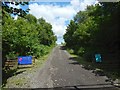
Track to Ardencaple Farm
The track is the same one as shown in Image, but the view is in the opposite direction, and is from under the bridge that is shown in that picture; the shadow of the bridge's railings can be seen in the foreground.
Image: © Lairich Rig
Taken: 14 Jul 2015
0.08 miles
9
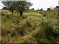
Remains of accommodation camp
Some concrete hut bases, remnants of an accommodation camp associated with an anti-aircraft battery, can be seen just to the right of the trees. The picture was taken from a Image
Image: © Lairich Rig
Taken: 19 Sep 2012
0.11 miles
10
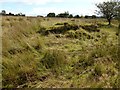
Remains of accommodation camp
See Image for context; the present picture was taken from that track, and it shows a concrete hut base, a relic of the accommodation camp.
Image: © Lairich Rig
Taken: 19 Sep 2012
0.12 miles