IMAGES TAKEN NEAR TO
Lady Clare Way, G84 7EQ
Introduction
This page details the photographs taken nearby to Lady Clare Way, G84 7EQ by members of the Geograph project.
The Geograph project started in 2005 with the aim of publishing, organising and preserving representative images for every square kilometre of Great Britain, Ireland and the Isle of Man.

There are currently over 7.5m images from over14,400 individuals and you can help contribute to the project by visiting https://www.geograph.org.uk
Image Map
Images are licensed for reuse under creativecommons.org/licenses/by-sa/2.0
Notes
- Clicking on the map will re-center to the selected point.
- The higher the marker number, the further away the image location is from the centre of the postcode.
Image Listing (17 Images Found)
Images are licensed for reuse under creativecommons.org/licenses/by-sa/2.0
Image
Details
Distance
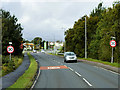
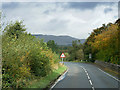
2
The A814 nearing Helensburgh
From directly opposite Iona Stables, looking west towards the town.
Image: © Stephen Sweeney
Taken: 19 Feb 2013
0.10 miles
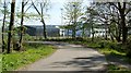
3
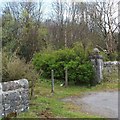
Old lodge gatepost
At this point, a greatly overgrown track heads north-east, away from the main road. The presence of an elaborate gatepost suggested that there might once have been a lodge here.
The lodge is shown on the first-edition OS map (c.1860); as later maps reveal, it was called Mid Lodge, and, as that name suggests, it was one of three that were associated with Camis Eskan House (Image). It was located in roughly the same place as the dense clump of vegetation that can be seen beside the gatepost.
The other two lodges survive: Image and Image
Image: © Lairich Rig
Taken: 13 Apr 2012
0.14 miles
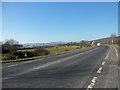
5
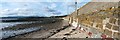
Sea wall at Craigendoran
While the incoming tide does reach the wall, the water level at high tide does not reach far above its base; presumably, the height of the wall is largely dictated by its other role, as an embankment for the railway line (compare Image).
The photograph was taken from near the south-eastern end of the wall. The railway line closely follows the top of the wall until the latter comes to an end about 450 metres further ahead. Also located near that point is Craigendoran Junction, where the West Highland Railway begins, branching from the main Dumbarton-to-Helensburgh line (see the 1:25000 map).
Image: © Lairich Rig
Taken: 17 Sep 2010
0.16 miles
6
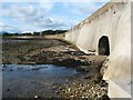
The Red Burn flowing through a sea wall
The wall also serves to carry a railway line, and it was presumably the latter role that dictated its height, since the water level does not extend far up the wall, even at high tide; see Image However, there is another reason why the presence of the tunnel does not conflict with the function of the sea wall: on the far side of the wall, the burn is safely confined by embankments on either side.
The photograph shows the Red Burn flowing out onto the beach, where it will empty into the Firth of Clyde. Compare Image, close to its source near Ben Bowie, and Image, which shows the surprisingly deep valley which it has carved out within a fairly short distance from its source.
Image: © Lairich Rig
Taken: 17 Sep 2010
0.16 miles
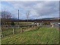
8
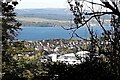
Lost Summer House
To the south east of Camis House, is a hill overlooking Craigendoran.
In 1860 the map shows the name “Summer Ho”. By 1890, the map shows just a dot.
All that remains is a ragged stone base. The length is approximate 20 metres. The Summer House was probably rotten many years ago.
There is a great view across the loch.
The Summer House was about 30 metres up from the old Ice House.
Image: © Pete Marrison
Taken: 10 Oct 2024
0.19 miles
9
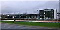
Hermitage Academy
The new school building is further east along the A814 from the old one Image
Image: © Thomas Nugent
Taken: 18 Mar 2011
0.19 miles
10
Hermitage Academy
See Image and Image for the location of the previous building, and Image for an earlier photo of the present building. The building was probably not in use (as a school) when the present photograph was taken, on account of the local council elections held on that day.
Image: © Lairich Rig
Taken: 3 May 2012
0.20 miles