IMAGES TAKEN NEAR TO
Cables Drive, ALEXANDRIA, G83 9EN
Introduction
This page details the photographs taken nearby to Cables Drive, G83 9EN by members of the Geograph project.
The Geograph project started in 2005 with the aim of publishing, organising and preserving representative images for every square kilometre of Great Britain, Ireland and the Isle of Man.

There are currently over 7.5m images from over14,400 individuals and you can help contribute to the project by visiting https://www.geograph.org.uk
Image Map
Images are licensed for reuse under creativecommons.org/licenses/by-sa/2.0
Notes
- Clicking on the map will re-center to the selected point.
- The higher the marker number, the further away the image location is from the centre of the postcode.
Image Listing (28 Images Found)
Images are licensed for reuse under creativecommons.org/licenses/by-sa/2.0
Image
Details
Distance
1
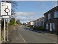
Entering Jamestown
John Neill's 1912 book "Records and Reminiscences of Bonhill Parish" offers, on page 43, an explanation for the name Jamestown. I cannot vouch for its correctness, but it is worth quoting here, for interest:
"In 1773 a schoolhouse was erected at Dam of Balloch, now called Jamestown, from the fact that three feuars whose individual Christian name was James, had each built a house there."
Image: © Lairich Rig
Taken: 15 Feb 2013
0.12 miles
2
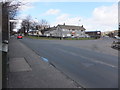
Auchincarroch Road
Junction with the A813. Auchincarroch Road leads to Auchencarroch (I wonder when the difference in spelling crept in?).
Image: © Barbara Carr
Taken: 21 Apr 2013
0.13 miles
3
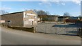
Garage on Auchincarroch Road
The premises, on Image, were closed for the Easter holidays.
Image: © Lairich Rig
Taken: 1 Apr 2013
0.15 miles
4
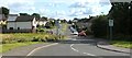
Napierston Road
The picture was taken from the junction with Image The area ahead is called Dalmonach (thought to signify "field of the monks"; compare Image).
The green area in the foreground, to the left (north) of the road was, until recent years, the site of Napierston Farm: Image The area called Napierston was also known historically as Bonhill-Napier (there was also a Bonhill-Noble and a Bonhill-Lindsay; see Image).
The land that came to be known as Bonhill-Napier or Napierston was granted to Duncan Napier by Walter, Earl of Lennox: "Walter bestowed the 'quarter' of Bonhill, lying next to the lands of Balloch, upon Duncan Napier, lord of Kilmahew, for services rendered by John Napier, his father, to Malcolm, Earl of Lennox, who was slain at Halidon Hill" [Joseph Irving in volume 2 of "The Book of Dumbartonshire" (1879)].
The battle of Halidon Hill took place in July 1333, and the grant is recorded as charter 68 in the Lennox Cartulary: "Carta terrarum de Bullul et Miltoun Duncano Naper", "charter of the lands of Bonhill and Miltoun to Duncan Nap(i)er". On the form "Bullul" for Bonhill, see Image
A "Napierstoun" is shown, somewhere in this general area, on the Pont/Blaeu map of the Lennox (the map was published in 1654, but was based largely upon surveys carried out in the 1580s-90s). Roy's Military Survey (1740s-50s) likewise shows "Napierstown".
By the time of the first-edition OS map (surveyed in 1860), Napierston Farm is shown here, with Woodside Farm a little further up Auchincarroch Road; that was still the case until less than a decade before this photograph was taken.
When the extensive Strathleven Estate was sold off in lots in 1950, these farms made up Lot 7. In some respects, the prospectus treats them as a single entity: they are listed as "another extremely fine T.T. dairy farm known as Napierston and Woodside". The two farms latterly belonged to the same family, which accounts for the fact that there is now a prominent "Napierston Farm" sign on one of the large farm buildings of Woodside Farm.
In 2007, shortly before the buildings of Napierston Farm were demolished, the area was archaeologically surveyed to determine whether there was evidence for the farm's location being at the centre of the medieval Napierston area (also known as Bonhill-Napier). No such evidence was found, but this was in line with expectations; it had been thought more likely that the core of the medieval settlement lay in what is now Bonhill (and it is probably that settlement, rather than the more recent farm, that was represented by "Napierstoun" on the Pont/Blaeu map).
Image: © Lairich Rig
Taken: 13 Aug 2010
0.15 miles
5
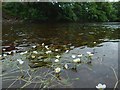
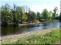
Water-crowfoot in the River Leven
(Ranunculus sp.)
The level of the river was low, making it easier to approach the plants, and causing the long stems to trail horizontally. The common name Water-crowfoot does not apply to just one species, but to several different ones that are superficially alike.
Image: © Lairich Rig
Taken: 22 Jun 2016
0.15 miles
6
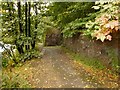
Footpath beside the River Leven
Alongside this section of the path is a wall, a relic of one of the buildings of Milton Works (a dyeworks that was already gone by the time of the Second World War). The River Leven itself is the bright area seen through the trees on the left.
Image: © Lairich Rig
Taken: 5 Oct 2012
0.16 miles
7
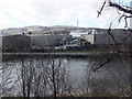
Loch Lomond Brewery
Viewed across the River Leven from the A813 south of Jamestown. See http://lochlomondbrewery.com/about-us .
Image: © Barbara Carr
Taken: 21 Apr 2013
0.16 miles
8
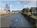
Auchincarroch Road
This picture was taken not far from the junction with Main Street, shown in Image; as explained there, this road forms one leg of a route known locally as the Horseshoe. In the present photograph, one of the entrances to some timber merchants' premises can be seen on the left: Image
For the main discussion of the name Auchincarroch, see Image, taken a little further along the road.
Image: © Lairich Rig
Taken: 15 Feb 2013
0.17 miles
9
A skimmer in the River Leven
The stone structure shown at the centre of the photograph is more visible than usual after a period of dry weather, which had lowered the Leven's level. It is a "skimmer", directing some of the flow of the river into a lade. In this case, the lade served Dalmonach Print Works (for which, see Image).
For other examples on the River Leven, see Image and Image
Image: © Lairich Rig
Taken: 2 May 2011
0.17 miles
10
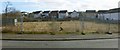
The former site of Napierston Farm
This is a view across Napierston Road. The open space behind the fence was the site of Napierston Farm, which was demolished in recent years. For much more information, see Image and Image
The houses in the background of the present photograph are in an area that is known as the Steadings, an allusion to the former presence of the farm.
For a view through the fence, see Image
Image: © Lairich Rig
Taken: 1 Mar 2013
0.17 miles