IMAGES TAKEN NEAR TO
Perray Avenue, DUMBARTON, G82 5JG
Introduction
This page details the photographs taken nearby to Perray Avenue, G82 5JG by members of the Geograph project.
The Geograph project started in 2005 with the aim of publishing, organising and preserving representative images for every square kilometre of Great Britain, Ireland and the Isle of Man.

There are currently over 7.5m images from over14,400 individuals and you can help contribute to the project by visiting https://www.geograph.org.uk
Image Map
Images are licensed for reuse under creativecommons.org/licenses/by-sa/2.0
Notes
- Clicking on the map will re-center to the selected point.
- The higher the marker number, the further away the image location is from the centre of the postcode.
Image Listing (63 Images Found)
Images are licensed for reuse under creativecommons.org/licenses/by-sa/2.0
Image
Details
Distance
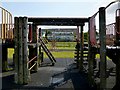
1
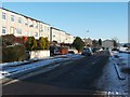
Perray Avenue, Hawthornhill
Perray Avenue is a short street attached to the northern side of Hawthornhill Road. About 350 metres to the west are the similarly-named Perrays Way, Drive, Crescent, Grove, and Court.
About 600 metres to the north-west of the point where the photograph was taken is a small square of woodland (Image) called Perrays Wood (visible on the left in Image); this makes the origin of all of these street names clear.
The same Image is mentioned in David Murray's book "Old Cardross: a lecture" (1880), where it is described as "the wood about halfway between Kellochy and Hawthornhill" (Kellochy, now long gone, was at Image; for Hawthornhill, see Image).
The same work adds that "The Perrays" were "the two fields on the north of Hawthornhill, on the east and west of the road to Ardochbeg" (on which, see Image).
Image: © Lairich Rig
Taken: 24 Dec 2010
0.01 miles
2
Path at Hawthornhill
To stay on the path to Dalmoak that is mentioned in the end-note, it is necessary to turn left just ahead: see Image for the view from just around the corner.
Image: © Lairich Rig
Taken: 13 Jul 2018
0.05 miles
3
Path at Hawthornhill
The view is the one obtained by turning left just after the point shown in Image For a view from about 70 metres further along this path, see Image, where the route to Dalmoak that is mentioned in the end-note leaves the area of housing.
Image: © Lairich Rig
Taken: 13 Jul 2018
0.05 miles
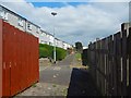
4
The former site of Hawthornhill Farm
The buildings of Hawthornhill Farm extended from the photographer's position to a point about 60 metres ahead (that is, to about the nearest of the lamp posts). The site of the farm buildings included what is now Hawthornhill Road, as well as parts of the flat grassy space just to its left (south).
A hedge-lined path that leads here from the south, Image, is now part of a public footpath, but it was originally the track leading from the main road (Cardross Road) to the farm. It is shown as such on the first-edition OS map (1860). Note that the present-day Cardross Road follows the same line as the road that existed in 1860.
The farm is marked, as Haithorn Hill, on the Blaeu map of the Lennox (1654), which was itself based on surveys carried out c.1580s—90s.
David Murray, in his "Old Cardross — A Lecture" (1880), states that an older name for the farm was Latriehill, which he explains as "wet hill slope". He is presumably deriving it from the Gaelic "leitir", in which case it would be better translated as "slope leading down to a body of water" (see the comments on "leitir" at Image for a reference). The map shows that this explanation would fit the farm's situation: the land slopes down to the Clyde. The later name for the farm requires no comment.
The Farm Horse Tax Rolls of 1797—98 show a Robert Taylor as the tenant here; at that time, David McArthur was the farmer at nearby Clarkhill (Clerkhill — see comments at Image).
The OS Name Books show that, by 1860, another Mr McArthur (presumably of the same family) was the tenant of Hawthornhill. Donald Macleod, in his "Past Worthies of the Lennox" (1894), tells an anecdote about Peter McArthur of Hawthornhill, who was notoriously scruffy when going about his farm business. Macleod's tale is about a tramp who just had been turned away from the farm. On leaving, he passed Peter, who was heading back home; taking Peter for a fellow tramp, he advised him that he was wasting his time there, as they were a miserable lot at Hawthornhill. Peter thanked him, and said he'd try his luck there anyway.
Another of the family, James McArthur, occupied nearby Havoc Farm in 1860: Image See also the comments at Image about his measuring to the back of the narrow cave with a pole.
Image: © Lairich Rig
Taken: 4 Sep 2018
0.05 miles
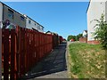
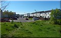
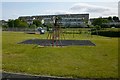
5
Play area at Hawthornhill
Being here with family gave an opportunity to show the area; see Image for a less obstructed view.
The buildings in the background are in Westcliff. Image is nearby. See Image for the surroundings.
Image: © Lairich Rig
Taken: 26 Jun 2013
0.05 miles
6
Dalreoch United Free Church of Scotland
Another contributor's earlier (2011) picture: Image
Image: © Lairich Rig
Taken: 7 Jun 2020
0.06 miles
7
Heading to Hawthornhill
After following the side of a hedge (Image) and then ascending a grassy slope, the route enters a built-up area here at Cumbrae Crescent South.
Image: © Lairich Rig
Taken: 6 May 2020
0.07 miles
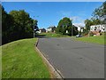
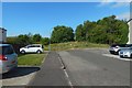
8
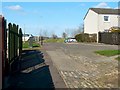
Cumbrae Crescent South, Hawthornhill
This is the western end of the street; for the other end, see Image
This area is also part of a core path from Hawthornhill to Dalmoak. That route leads uphill from Cardross Road (see Image), then cuts through Image to emerge at the point from which the present photograph was taken. It then continues directly ahead, leaving Hawthornhill by means of the western end of Cumbrae Crescent South, just left of the centre of the photo.
At that point, the route leaves the built-up area behind; for the view from that spot, see Image
Image: © Lairich Rig
Taken: 24 Mar 2011
0.07 miles
9
Play area at Hawthornhill
See Image, taken on the same occasion, for comments on the area. The houses in the background are in Westcliff.
Image: © Lairich Rig
Taken: 26 Jun 2013
0.07 miles
10
Path at Hawthornhill
The view is from about 70 metres further along the path shown in Image, continuing in the same direction.
At this point, the route to Dalmoak that is mentioned in the end-note leaves the area of housing, and carries on straight ahead, through a gap in the trees. It then leads down a slope, as shown in Image
Image: © Lairich Rig
Taken: 13 Jul 2018
0.07 miles