IMAGES TAKEN NEAR TO
DUMBARTON, G82 4HQ
Introduction
This page details the photographs taken nearby to G82 4HQ by members of the Geograph project.
The Geograph project started in 2005 with the aim of publishing, organising and preserving representative images for every square kilometre of Great Britain, Ireland and the Isle of Man.

There are currently over 7.5m images from over14,400 individuals and you can help contribute to the project by visiting https://www.geograph.org.uk
Image Map
Images are licensed for reuse under creativecommons.org/licenses/by-sa/2.0
Notes
- Clicking on the map will re-center to the selected point.
- The higher the marker number, the further away the image location is from the centre of the postcode.
Image Listing (40 Images Found)
Images are licensed for reuse under creativecommons.org/licenses/by-sa/2.0
Image
Details
Distance
1
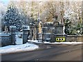
Mains Lodge
This building is located alongside Renton Road, at the entrance of a driveway leading to Image, which was built in 1866-68 for John Aiken (see that link for further details).
For further information about the gate and gatepiers that are shown in this photograph, see the listed building report: http://portal.historic-scotland.gov.uk/designation/LB1163 (at Historic Environment Scotland).
However, one correction should be made to what is said there: the first owner was John Aiken (the correct spelling of the surname); James, named in that report, was his eldest son.
Image: © Lairich Rig
Taken: 24 Dec 2010
0.00 miles
2
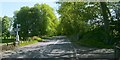
Renton Road
The signposts to the left of the road indicate the Image, and of footpaths to Cardross and Hawthornhill. See also Image, looking back towards this junction.
Image: © Lairich Rig
Taken: 30 Apr 2011
0.02 miles
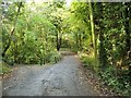
3
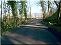
Path to Dalmoak
The short section of the Kipperoch Road shown here is part of two core paths to Dalmoak, one from Cardross, the other from Hawthornhill. Ahead, both routes end at the main road: Image
A large building is visible to the left, beyond the end of the path; it is part of Dalmoak Farm (Image). In the distant background, directly beyond the far end of the path, are the Lang Craigs, the escarpment of the Kilpatrick Hills: Image
For a view of the same section of road in the opposite direction, see Image, which shows where the two distinct routes divide.
Image: © Lairich Rig
Taken: 24 Mar 2011
0.03 miles
4
Dalmoak Farm from the A812
View northward, from the bus stop south of the stream which flows eastward to join the River Leven near Dumbarton.
Image: © Barbara Carr
Taken: 21 Apr 2013
0.03 miles
5
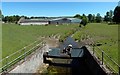
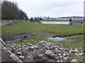
Whiteleys Burn at Dalmoak Farm
The farm, known locally as Young's Farm, is shown in Image / Image / Image, the last of these having been taken on the same occasion as the present picture.
Image: © Lairich Rig
Taken: 30 Jun 2018
0.04 miles
6
Start of the Kipperoch Road
This photo was taken from the point where the road branches off from the A812: Image
(Compare Image, a view in the opposite direction over the same section of road as shown in the present photograph.)
A wooden signpost can be seen at the point where the road forks. For the Kipperoch Road, which continues straight ahead, the sign says "Footpath to Cardross 4 km".
For the other track that branches off to the left, the sign says "Footpath to Hawthornhill 1 km". For the first part of that route, see Image
Image: © Lairich Rig
Taken: 20 Oct 2006
0.04 miles
7
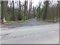
Road into Dalmoak House estate
Junction with the A812 just south of Dalmoak Farm.
Image: © Barbara Carr
Taken: 21 Apr 2013
0.05 miles
8
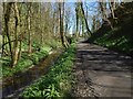
Path to the Renton Road
The Whiteleys Burn is on the left. Wild Garlic is growing beside the path. Not far ahead, this route meets the Kipperoch Road. The junction is shown, from the other side, in Image
The same part of the route is shown, but in the opposite direction, and in a different season, in Image
Image: © Lairich Rig
Taken: 20 Apr 2016
0.06 miles
9
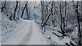
Path to Hawthornhill
This is the start of the path that is shown branching off to the left in Image The frozen Whiteleys Burn is on the right. For a view in the opposite direction, in a different season, see Image
For the next part of the route, see Image
Image: © Lairich Rig
Taken: 24 Dec 2010
0.06 miles
10
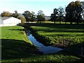
Whiteleys Burn passing Dalmoak Farm
The photo was taken from the roadside, near Dalmoak Lodge; see also Image
For further information, see Image
At roughly the point from which this picture was taken, there is an OS benchmark on top of the stone wall which runs between the pavement and this field; I didn't get around to uploading a picture of it.
Image: © Lairich Rig
Taken: 16 Oct 2009
0.06 miles