IMAGES TAKEN NEAR TO
Dumbuck Road, DUMBARTON, G82 3NB
Introduction
This page details the photographs taken nearby to Dumbuck Road, G82 3NB by members of the Geograph project.
The Geograph project started in 2005 with the aim of publishing, organising and preserving representative images for every square kilometre of Great Britain, Ireland and the Isle of Man.

There are currently over 7.5m images from over14,400 individuals and you can help contribute to the project by visiting https://www.geograph.org.uk
Image Map
Images are licensed for reuse under creativecommons.org/licenses/by-sa/2.0
Notes
- Clicking on the map will re-center to the selected point.
- The higher the marker number, the further away the image location is from the centre of the postcode.
Image Listing (132 Images Found)
Images are licensed for reuse under creativecommons.org/licenses/by-sa/2.0
Image
Details
Distance
1
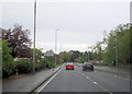
A82 at entrance to Police HQ in Silverton
Image: © John Firth
Taken: 11 May 2012
0.03 miles
2
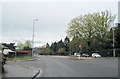
A82 road junction at Silverton
A82 junction with Round Riding Road
Image: © John Firth
Taken: 11 May 2012
0.04 miles
3
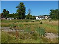
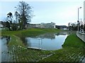
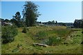
Flood storage pond at Garshake
The pond is empty after a prolonged period of dry weather; see Image for a view from another angle.
The buildings in the background are on the other side of Garshake Road. Those on the left are beside the main entrance of Dumbarton Cemetery.
Image: © Lairich Rig
Taken: 29 Jun 2018
0.04 miles
4
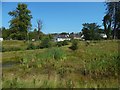
Flood storage pond at Garshake
This is a view across the area shown in the foreground of Image Garshake Road runs behind it. The small building at the far left is beside Dumbarton Cemetery and is the offices of a firm of memorial sculptors.
Image: © Lairich Rig
Taken: 25 Aug 2019
0.04 miles
5
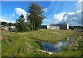
Flood storage pond at Garshake
See Image for the same area at an earlier stage in the construction process, and Image for a later view. In both pictures, Image can be seen in the background.
Image: © Lairich Rig
Taken: 12 Dec 2014
0.05 miles
6
Flood storage pond at Garshake
Image are in the background.
The pond is shown under construction in Image, and with more water in Image
Image: © Lairich Rig
Taken: 4 Sep 2016
0.05 miles
7
Flood storage pond at Garshake
The pond is empty after some prolonged dry weather; compare Image See Image for a view from another angle.
When the present picture was taken, the former Image behind the pond had been superseded by the Image
Image: © Lairich Rig
Taken: 29 Jun 2018
0.05 miles
8
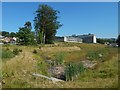
Work on flood defences
The picture shows the construction of flood defences on the Knowle Burn at Garshake. Image are in the background.
See Image and Image for later views.
Image: © Lairich Rig
Taken: 27 Jun 2014
0.05 miles
9
Flood storage pond at Garshake
The County Buildings, shown in the background of an equivalent earlier view, Image, have been reduced to rubble.
Image: © Lairich Rig
Taken: 25 Aug 2019
0.05 miles
10
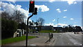
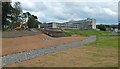
Stirling Road at West Dunbartonshire Council Offices
West Dunbartonshire Council's offices are visible straight ahead. There is an entrance to Dumbarton Cemetery on the left.
Image: © Richard Cooke
Taken: 9 Apr 2016
0.05 miles