IMAGES TAKEN NEAR TO
DUMBARTON, G82 2SH
Introduction
This page details the photographs taken nearby to G82 2SH by members of the Geograph project.
The Geograph project started in 2005 with the aim of publishing, organising and preserving representative images for every square kilometre of Great Britain, Ireland and the Isle of Man.

There are currently over 7.5m images from over14,400 individuals and you can help contribute to the project by visiting https://www.geograph.org.uk
Image Map
Images are licensed for reuse under creativecommons.org/licenses/by-sa/2.0
Notes
- Clicking on the map will re-center to the selected point.
- The higher the marker number, the further away the image location is from the centre of the postcode.
Image Listing (52 Images Found)
Images are licensed for reuse under creativecommons.org/licenses/by-sa/2.0
Image
Details
Distance
1
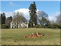
Barnhill House
This photograph of Barnhill House was taken from a nearby public footpath. For a view of that footpath, and of the lodge at Barnhill, see: Image
The building, as it now stands, is largely of nineteenth-century construction, but Barnhill was the seat of the Colquhouns from at least as early as the sixteenth century: see Image
See also Image, which shows some of the other buildings at this location.
Image: © Lairich Rig
Taken: 21 Mar 2008
0.01 miles
2
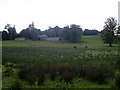
Barnhill from road to Overtoun House
Image: © Stephen Sweeney
Taken: 31 May 2008
0.04 miles
3
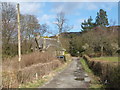
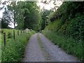
The Lodge at Barnhill
The lodge visible here is one of a group of buildings at Barnhill. The lodge stands alone, while some of the other buildings that make up Barnhill are clustered together about 200 metres to the north-west: Image
The footpath in this photograph is part of a route called Overtoun House Circular Path. A small sign is visible ahead, at a T-junction: the sign reminds walkers that the circular path continues to the right; the other branch, to the left, is a private road, and leads past the lodge and towards Barnhill House.
Image: © Lairich Rig
Taken: 21 Mar 2008
0.10 miles
4
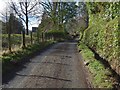
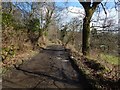
Overtoun House Circular Path
The path passes Carnoch House here. It is part of the old road to Barnhill that is described in the end-note.
Image: © Lairich Rig
Taken: 1 Mar 2017
0.10 miles
5
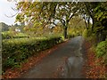
Overtoun House Circular Path
This is the opposite view to Image The path is part of the old road mentioned in the end-note.
The woods to the left (north) of the path are marked on the map. Large-scale mapping shows the names Barwood Hill and Dumbar there.
A nearby house is called Barnhill: Image I believe it was, at a very early period, called Barhill, thus relating it, by the "bar" element, to the other names just mentioned; however, I cannot find a reference to confirm this at the moment. At any rate, it appears as "Barnhill" (the current spelling) on the Blaeu map of the Lennox, which is based on surveys made c.1580s—90s.
Image: © Lairich Rig
Taken: 1 Mar 2017
0.13 miles
6
Milton Brae
The building on the left is Image, and the one closer to the centre of the photo is its former lodge: Image One of the entrances of the Overtoun Estate is visible at the far end of the road; see Image
For the more southerly sections of the road, see Image and Image
Image: © Lairich Rig
Taken: 18 Oct 2012
0.13 miles
7
Path to Barnhill Road
Part of the Overtoun House Circular Path.
Image: © Stephen Sweeney
Taken: 31 May 2008
0.13 miles
8
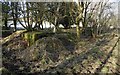
WWII remains near Middleton Farm
These ruins are beside the road leading into Overtoun Estate. See Image for the main description of the remains to be seen in this area. Click on the end-note title for other views.
Image: © Lairich Rig
Taken: 6 Feb 2015
0.13 miles
9
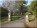
Entrance to Overtoun Estate
The road leading to this entrance from the south is called Milton Brae. Followed in this direction, the road leads to Image
Image: © Lairich Rig
Taken: 28 Feb 2016
0.13 miles
10
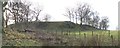
Ravens' Craig
This rocky knoll is about midway between Image and Image The name Image refers specifically to the steep slopes on the right.
Image: © Lairich Rig
Taken: 2 Dec 2011
0.14 miles