IMAGES TAKEN NEAR TO
DUMBARTON, G82 2SE
Introduction
This page details the photographs taken nearby to G82 2SE by members of the Geograph project.
The Geograph project started in 2005 with the aim of publishing, organising and preserving representative images for every square kilometre of Great Britain, Ireland and the Isle of Man.

There are currently over 7.5m images from over14,400 individuals and you can help contribute to the project by visiting https://www.geograph.org.uk
Image Map
Images are licensed for reuse under creativecommons.org/licenses/by-sa/2.0
Notes
- Clicking on the map will re-center to the selected point.
- The higher the marker number, the further away the image location is from the centre of the postcode.
Image Listing (62 Images Found)
Images are licensed for reuse under creativecommons.org/licenses/by-sa/2.0
Image
Details
Distance
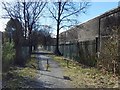
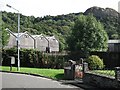
1

Path from the Dumbuck House Hotel
This is the northeastern end of the path referred to in the end-note (see Image for a view in the opposite direction from the same point.
The busy A82 is just beyond the gateposts that are slightly right of centre. The nearer path running across the width of the image is a cycle path (NCN 7) and footpath.
As for the building standing left of centre, the first-edition OS map (1860) shows a building there, marked "Lodge", presumably that of Image, which is at the other end of the path. The lodge is now a private dwelling, and I have therefore tried to show it here in a way that is not intrusive.
The first-edition map shows a road leading from the lodge to Dumbuck House (as it then was), although a railway line (now long gone) was by then cutting across the middle of the road between lodge and house (Dumbuck House pre-dates that railway line).
The road between the lodge and the house is now a right of way, a footpath from the cycle route (NCN 7) to what is now a hotel. The course of the railway line that used to cut across the road between the lodge and Dumbuck House corresponds to the line of a road (not a public one) that cuts across the middle of the path, as shown in Image; that road is employed in connection with the bonded warehouses in that area.
The cycle path elsewhere follows the trackbed of the old railway line, but not here, on account of the presence of the bonded warehouses. That is clearly seen on the 1:25000 map, where NCN 7 is marked with orange dots; the above account explains why it deviates here.
Image: © Lairich Rig
Taken: 23 Mar 2018
0.01 miles
2
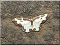
A moth - Clouded Border (Lomaspilis marginata)
In this species, the pattern of brown markings on the wings can vary a great deal between one individual and another.
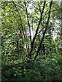
This species is generally found in wooded areas, but the moth shown here was working its way along a stone wall near the busy A82. However, on the other side of the stone wall, a cycle path that runs parallel to it is bordered by a long narrow wooded area, and there is also a more extensive area of woodland on the other side of the A82.
Caterpillar: Image
Image: © Lairich Rig
Taken: 13 Jun 2008
0.02 miles
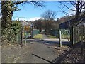
3
Start of a path to the Dumbuck House Hotel
This is the northeastern end of the path; shown with autumn colours in Image It begins here, branching off at right angles from the cycle route, NCN 7. The path is signposted at this end as:
"Path
Dumbuck Hotel / A814
300 yds"
There are bonded warehouses on both sides of the path. I have used the name "Dumbuck House Hotel", rather than what appears on the sign, since (at the time of writing) that is what appears on the building itself: Image
Image: © Lairich Rig
Taken: 9 Mar 2018
0.03 miles
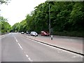
4
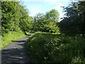
Cycle Route 7 at Dumbuck
This section of the cycle path begins at the junction of Image (see that item for more details) and Image
The unseen A82 is just to the left, behind a wall and some trees; the silhouette of a building can be made out on the right; it is one of the Image that are located in this area.
Image: © Lairich Rig
Taken: 10 Jun 2011
0.04 miles
5
Path to the Dumbuck Hotel
The signposted path leads from Image to Image This is the northeastern end, shown without the autumnal foliage in Image
The buildings to either side are Image (also shown in Image and Image).
Image: © Lairich Rig
Taken: 26 Oct 2012
0.07 miles
6
Bonded warehouses
View towards Dumbuck Hill from Third Avenue past the Ballentyne bonded warehouses. Everything around here is blackened by the usual whisky fungus, including the postman's drop box (left).
Image: © Richard Webb
Taken: 1 Sep 2009
0.08 miles
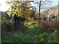
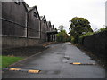
7
Path from the Dumbuck House Hotel
At this point, roughly halfway along its length, the path is crossed by a road that is associated with the bonded warehouses on either side; as would be expected, the gates on either side of the footpath are closed except on the infrequent occasions when vehicles are using that road; the path itself is not blocked.
The road corresponds to the course of a railway line, now long gone. As the 1:25000 map shows, a cycle route (NCN 7) follows the former course of the railway line nearby, but does not do so here, on account of the bonded warehouses; the cycle path goes around them instead.
Image: © Lairich Rig
Taken: 9 Mar 2018
0.08 miles
8
Bonded warehouses at Dumbuck
In the Dumbuck area, between Bowling and Dumbarton, there is a considerable acreage of bonded warehouses. The straight private road passing behind some of these was once the North British Railway route from Glasgow Queen Street to Dumbarton, Helensburgh and the West Highland line. In the 1960s, however, when British Railways was electrifying the route, it was the former Caledonian Railway line westward from Dumbuck through Dumbarton East station that was "wired" and the North British line that was closed. One wonders whether the short canopied platform was served by a siding when the railway was open.
Image: © A-M-Jervis
Taken: 13 Oct 2007
0.08 miles
10
Trackside vegetation, Dumbuck
The trees beside the National Cycle Route 7 (Glasgow to Balloch) and former Caledonian and Dunbartonshire Junction Railway, have blackened trunks. This betrays the presence of the whisky industry, the black being a fungus which lives off ethanol in the air. All surfaces near bonded warehouses are blackened by this fungus.
Image: © Richard Webb
Taken: 1 Sep 2009
0.10 miles