IMAGES TAKEN NEAR TO
Ranfurly Drive, GLASGOW, G68 0DR
Introduction
This page details the photographs taken nearby to Ranfurly Drive, G68 0DR by members of the Geograph project.
The Geograph project started in 2005 with the aim of publishing, organising and preserving representative images for every square kilometre of Great Britain, Ireland and the Isle of Man.

There are currently over 7.5m images from over14,400 individuals and you can help contribute to the project by visiting https://www.geograph.org.uk
Image Map
Images are licensed for reuse under creativecommons.org/licenses/by-sa/2.0
Notes
- Clicking on the map will re-center to the selected point.
- The higher the marker number, the further away the image location is from the centre of the postcode.
Image Listing (12 Images Found)
Images are licensed for reuse under creativecommons.org/licenses/by-sa/2.0
Image
Details
Distance
1
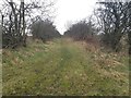
The auld cley road
This road has been used for thousands of years and is shown in lots of old maps. It was a vital road which made travelling through Dullatur bogs possible before the marshes were drained. Robert the Bruce supposedly gathered his troops nearby at the Carrickstone. The views of the Clyde valley, Campies and Kilsyth hills are still good and would have been more so before modern housing had been built.
Image: © carrickstone emily
Taken: 6 Jan 2012
0.07 miles
2
Auld cley road
This is a modern path which follows an old parish/Roman road, leading towards Cumbernauld community park, further along this road, the original track is more evident. It is recorded as Roman and Drovers...via Flavii. On this road is the Carrickstone which is said to be the meeting place of Robert the Bruce. A good view of the surrounding valleys is evident further on.
Image: © carrickstone emily
Taken: 6 Jan 2012
0.07 miles
3
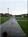
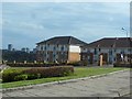
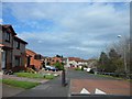
Cathkin Crescent, Carrickstone
Looking south-westward.
Image: © Peter Wood
Taken: 3 Oct 2020
0.11 miles
4
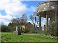
Carrickstone water tower
Until recently Carrickstone was a hilltop farm, the trigpoint in a hedge at the side of a lane. Now it has been swallowed up by new housing in Cumbernauld. The water tower is a hilltop landmark.
Image: © Richard Webb
Taken: 7 Apr 2005
0.12 miles
5
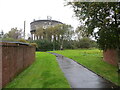
Pathway and Water Tower at Carrickstone
Looking northward. Carrickstone Triangulation Pillar can also be seen.
Image: © Peter Wood
Taken: 3 Oct 2020
0.12 miles
6
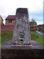
The Carrick Stone
Allegedly a Roman altar. It certainly looks as if it could have been part of a bigger object. The long since demolished Carrickstone farm and the present surrounding suburb is named after the stone.
Image: © Robert Murray
Taken: 9 Jun 2007
0.15 miles
7
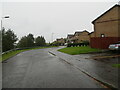
Portland Road, Carrickstone
And a distant view across Cumbernauld.
Image: © Stephen Sweeney
Taken: 16 Apr 2014
0.18 miles
8
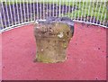
Carrickstone Trig
Situated just a few steps away from the Carrick Stone in this high spot of Cumbernauld.
Image: © Robert Murray
Taken: 9 Jun 2007
0.19 miles
10
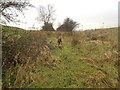
Auld cley road, Carrickstone, Cumbernauld, beginning of evident hedgerow on both sides, unmodernised
This shows the old road beside modern Cumbernauld primary school, which is unmodernised. Damson trees and Hawthorn dominate, whose ancestors may have been planted by the Romans. The Romans often used Damsons to flavour their wine.
Image: © carrickstone emily
Taken: 6 Jan 2012
0.20 miles