IMAGES TAKEN NEAR TO
Blanefield, GLASGOW, G63 9AT
Introduction
This page details the photographs taken nearby to G63 9AT by members of the Geograph project.
The Geograph project started in 2005 with the aim of publishing, organising and preserving representative images for every square kilometre of Great Britain, Ireland and the Isle of Man.

There are currently over 7.5m images from over14,400 individuals and you can help contribute to the project by visiting https://www.geograph.org.uk
Image Map
Images are licensed for reuse under creativecommons.org/licenses/by-sa/2.0
Notes
- Clicking on the map will re-center to the selected point.
- The higher the marker number, the further away the image location is from the centre of the postcode.
Image Listing (11 Images Found)
Images are licensed for reuse under creativecommons.org/licenses/by-sa/2.0
Image
Details
Distance
![Carbeth, Cuilts Road [2]](https://s2.geograph.org.uk/geophotos/04/04/07/4040730_10e9980f_120x120.jpg)
2
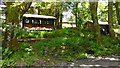
Carbeth, Cuilts Road
A few modern cabins in the woods here.
Image: © Robert Murray
Taken: 20 Jun 2014
0.09 miles
3
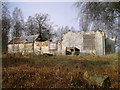
Ruin near B821
This ruin lies east of Carbeth Guthrie house and a little south of the B821.
Image: © Mark Nightingale
Taken: 3 Mar 2010
0.19 miles
4
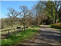
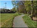
The John Muir Way at Carbeth Huts
The small post just to the left of the path has a marker for the John Muir Way: this path is part of the walkers' route from Balloch to Strathblane.
The map shows that the ground is lower to the north, which corresponds to the open grassy area visible to the left.
Image: © Lairich Rig
Taken: 9 May 2016
0.19 miles
5
Dappled shade, B821
There is a small informal lay-by at this point at the side of the road.
Image: © Richard Sutcliffe
Taken: 5 Sep 2015
0.22 miles
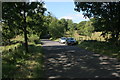
6
The John Muir Way at Carbeth Huts
The path, which is clearly new, and which is therefore not, at the time I am writing this, marked on the map, is part of the John Muir Way: specifically, it is on the walkers' route from Strathblane to Balloch; that new part of the route opened in 2016 (complementing an existing route, for cyclists as well as walkers, between those places).
For the hutters' community here, see Image Secret Scotland has a page – http://www.secretscotland.org.uk/index.php/Secrets/CarbethHuts – about it; for the Craigallian Fire mentioned there, see http://www.geograph.org.uk/snippet/12126
Image: © Lairich Rig
Taken: 9 May 2016
0.23 miles
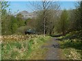
7
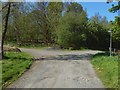
The John Muir Way near Carbeth Huts
The walkers' route from Balloch to Strathblane (complementing the existing cyclists' route between those places) opened in 2016. As the John Muir Way markers on the post visible at the right indicate, the route (when being followed from Strathblane to Balloch) leads directly ahead, and takes the left turning at this junction. Near here, it leads past the Carbeth Huts.
For a view of this junction from the other side of the gate shown on the left, see Image
The right turning is not part of the John Muir Way, but leads north to the B821: recent OS maps, perhaps by some misapprehension on the part of those revising them, call that part of the road Ballachalairy Yett; for the original application of the name, see Image
Image: © Lairich Rig
Taken: 9 May 2016
0.23 miles
8
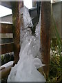
Ice formed from trough pipe leak
With the temperature significantly above freezing on a sunny day this large piece of ice was a surprising phenomenon. The black pipe visible at the top of the photograph feeds the water trough in the background. A small leak in the pipe seems to have been responsible for creating the large chunk of ice, presumably when the temperature had plunged well below freezing overnight.
Image: © Mark Nightingale
Taken: 3 Mar 2010
0.23 miles
9
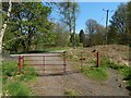
Gate beside junction
The same junction is shown, viewed from the track on the right, in Image The gate on the left in that picture is in the foreground here.
The tracks meeting here are marked on the 1:25000 and 1:50000 maps.
In relation to the present picture, the walkers' route from Balloch to Strathblane on the John Muir Way leads directly ahead, past this gate, and then to the right, as indicated by some markers on the post that is visible beyond the left-hand side of the gate.
Image: © Lairich Rig
Taken: 9 May 2016
0.24 miles
10
The John Muir Way near Carbeth Huts
The view is from about the same place as Image, but in the opposite direction. One example of a hut can be seen, with Dumgoyne (Image) on the skyline behind it.
The settlement of the Carbeth Hutters might be said to have had its roots in the summer camps organised here by the Clarion Scouts, a socialist movement, before the First World War. From those beginnings, the nature of the settlements gradually evolved in response to social changes.
Image: © Lairich Rig
Taken: 9 May 2016
0.24 miles