IMAGES TAKEN NEAR TO
South Field, UMBERLEIGH, EX37 9JE
Introduction
This page details the photographs taken nearby to South Field, EX37 9JE by members of the Geograph project.
The Geograph project started in 2005 with the aim of publishing, organising and preserving representative images for every square kilometre of Great Britain, Ireland and the Isle of Man.

There are currently over 7.5m images from over14,400 individuals and you can help contribute to the project by visiting https://www.geograph.org.uk
Image Map
Images are licensed for reuse under creativecommons.org/licenses/by-sa/2.0
Notes
- Clicking on the map will re-center to the selected point.
- The higher the marker number, the further away the image location is from the centre of the postcode.
Image Listing (44 Images Found)
Images are licensed for reuse under creativecommons.org/licenses/by-sa/2.0
Image
Details
Distance
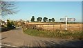
1
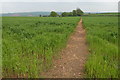
Footpath to Hayne Barton
The footpath passes through this field from the village of Burrington to a farm at Hayne Barton.
Image: © Philip Halling
Taken: 14 May 2006
0.06 miles
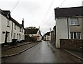
4
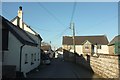
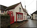
Village street, Burrington
The C18 (possibly also C17) Homelands, on the right, has a crest of the Earl of Plymouth on the projecting porch gable http://northdevon.gov.uk/media/290583/li-list_burr-chulm.pdf .
Image: © Derek Harper
Taken: 30 Nov 2016
0.15 miles
5
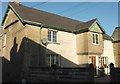
Homelands, Burrington
Also visible in Image The crest on the jettied porch "features an Earls Coronet above the letter ‘P’. The house belonged to the Earl of Plymouth who owned an estate in the parish of Burrington, but it is unclear whether the Earl ever stayed here or if his estate was simply administered by others from this house." http://northdevon.gov.uk/media/290583/li-list_burr-chulm.pdf .
Image: © Derek Harper
Taken: 30 Nov 2016
0.15 miles
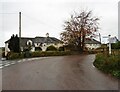
6
Balls Corner
The road from Colleton Mills tuns sharply right here at the junction with a steep lane up from Balls Bridge, and immediately picks up houses at the edge of the village of Burrington.
Image: © Derek Harper
Taken: 30 Nov 2016
0.15 miles
8
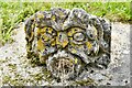
Burrington, Holy Trinity Church: Gargoyle in the churchyard
Presumably this was once on the church itself.
Image: © Michael Garlick
Taken: 14 Jun 2021
0.16 miles