IMAGES TAKEN NEAR TO
Dalwood, AXMINSTER, EX13 7HJ
Introduction
This page details the photographs taken nearby to EX13 7HJ by members of the Geograph project.
The Geograph project started in 2005 with the aim of publishing, organising and preserving representative images for every square kilometre of Great Britain, Ireland and the Isle of Man.

There are currently over 7.5m images from over14,400 individuals and you can help contribute to the project by visiting https://www.geograph.org.uk
Image Map
Images are licensed for reuse under creativecommons.org/licenses/by-sa/2.0
Notes
- Clicking on the map will re-center to the selected point.
- The higher the marker number, the further away the image location is from the centre of the postcode.
Image Listing (10 Images Found)
Images are licensed for reuse under creativecommons.org/licenses/by-sa/2.0
Image
Details
Distance
2
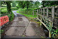
Lower Corry Ford
This ford is found on the byway at Lower Corry.
Image: © John Walton
Taken: 5 Jun 2017
0.09 miles
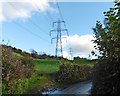
3
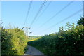
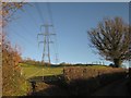
Power Lines at Lower Corry
This power line runs from a very large substation at Broadclyst in the Clyst valley just north of Exeter to a small substation near Axminster. The lane under them is the minor road from Dalwood to Stockland.
Image: © Nigel Mykura
Taken: 7 Aug 2015
0.10 miles
4
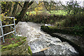
Stockland: Corry Brook
Just below a ford, usually dry, near Lower Corry. Looking south-south-east
Image: © Martin Bodman
Taken: 26 Nov 2006
0.11 miles
5
Fields at Lower Corry
These steep sloping pasture fields with the bright early morning sun on the fresh dew are on the western slopes of Horner Hill, viewed through an open gateway from the minor road between Dalwood Lane and Pennyhill Farm. The wood in the distance is Putt's Copse.
Image: © Nigel Mykura
Taken: 7 Aug 2015
0.13 miles
6
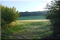
Corry Brook valley
From Dalwood Footpath 24 near the foot of the steep field shown in Image] and Image Beyond Lower Corry, a tree-lined route with public access follows an old track from a ford across the brook to the hamlet of Ham.
Image: © Derek Harper
Taken: 5 Dec 2012
0.17 miles
7
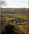
Field by the Corry Brook
Looking more to the right across the field shown in Image The 1:25000 sheet shows a now-vanished field boundary which looped across from the angle on the left to the trees on the right. Across the Corry Brook are Higher Corrie Farm (left) and Harrison Farm (centre, behind a pylon). Off to the right is Ham. Dominating the skyline is the tranmssion mast on Stockland Hill.
Image: © Derek Harper
Taken: 5 Dec 2012
0.18 miles
8
Field and pylons on Horner Hill
From the lane between Lower Corry and Dalwood. This is the pylon line seen in Image
Image: © Derek Harper
Taken: 5 Dec 2012
0.20 miles
9
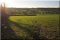
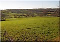
Field by the Corry Brook
A large field which crosses into Image before reaching the brook, indicated by the continuous line of trees. Seen from the lane between Dalwood and Lower Corry.
Image: © Derek Harper
Taken: 5 Dec 2012
0.21 miles
10
Electricity power lines near Lower Corry
Image: © Roger Cornfoot
Taken: 8 Nov 2017
0.22 miles