IMAGES TAKEN NEAR TO
Sidney Road, LONDON, E7 0EF
Introduction
This page details the photographs taken nearby to Sidney Road, E7 0EF by members of the Geograph project.
The Geograph project started in 2005 with the aim of publishing, organising and preserving representative images for every square kilometre of Great Britain, Ireland and the Isle of Man.

There are currently over 7.5m images from over14,400 individuals and you can help contribute to the project by visiting https://www.geograph.org.uk
Image Map
Images are licensed for reuse under creativecommons.org/licenses/by-sa/2.0
Notes
- Clicking on the map will re-center to the selected point.
- The higher the marker number, the further away the image location is from the centre of the postcode.
Image Listing (24 Images Found)
Images are licensed for reuse under creativecommons.org/licenses/by-sa/2.0
Image
Details
Distance
1
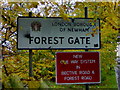
Arriving in Forest Gate
This is where you arrive in the northernmost part of Forest Gate, with Wanstead Flats on the left and Centre Road on the right.
Image: © Mike Richardson
Taken: 20 Nov 2006
0.10 miles
2
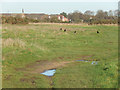
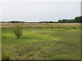
Wanstead Flats
Wanstead Flats cover 135 hectares and form the southernmost part of Epping Forest. Despite various attempts over the years to develop them, they remain a treasured open space in an otherwise heavily built-up area.
Image: © Stephen McKay
Taken: 23 Dec 2015
0.15 miles
3
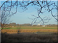
Angel Pond, Wanstead Flats
Angel (or, more correctly Angell) Pond was named after Lewis Angell, the first borough engineer of West Ham. It is not really much of a pond, more an area of boggy ground even in this winter view. Wanstead Flats is the most southerly part of Epping Forest.
Image: © Stephen McKay
Taken: 23 Dec 2015
0.16 miles
4
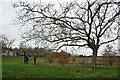
South western corner of Wanstead Flats
Taken from Capel Road looking towards Woodford Road.
Image: © Trevor Harris
Taken: 12 Dec 2020
0.16 miles
5
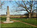
Joseph Fry Drinking Fountain, Wanstead Flats
The fountain at the southern end of Wanstead Flats was erected in memory of Joseph Fry (1809-1896) who had organised the construction of many drinking fountains, for people and horses, around London.
Image: © Stephen McKay
Taken: 23 Dec 2015
0.16 miles
6
Bandstand or Angell Pond
Not so much a pond in July 2011, more like a boggy puddle.
The pond was named after Lewis Angell, who was responsible for the construction of the pond during the winter of 1893-94.
At one time there was a bandstand nearby, which is why it is sometimes referred to as Bandstand pond.
Image: © Roger Jones
Taken: 14 Jul 2011
0.16 miles
8
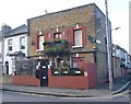
A distinctive house in Pevensey Road
This house is on the corner of Pevensey Road and Hesketh Road. It is fortunate that there is an outside post box as there are at least six notices on the front, warning of dogs.
Image: © Marathon
Taken: 14 Jan 2015
0.17 miles
9
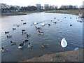
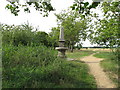
Jubilee Pond, Wanstead Flats
Wanstead Flats form the southernmost portion of Epping Forest. A perambulation of 1225 defined the southern boundary of Epping Forest as the main road from Bow Bridge via Stratford to Romford. The woodland extended south at least as far as Plashet at the time of the Domesday Book of 1086 (Plashet was a Norman-French name meaning a type of forest enclosure). Most of the woodland on what is now Wanstead Flats disappeared during the Middle Ages, and by the end of the 18th century the only unenclosed forest here was a few pieces on the southern fringe of Wanstead Flats. Further enclosure of the flats by Earl Cowley in 1871 caused protests, led by the City of London which was a commoner of the Forest after the purchase of Aldersbrook Farm to build the City of London Cemetery. These protests eventually led to the Epping Forest Act of 1878, which preserved the remaining Forest, including Wanstead Flats, from further encroachment or enclosure.
This is Jubilee Pond, near Lake House Road and Dames Road, late on a chilly winter's afternoon.
Image: © Marathon
Taken: 14 Jan 2015
0.17 miles
10
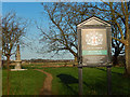
Wanstead Flats
The southern end of Epping forest marked by this City of London information board.
Image: © Stephen McKay
Taken: 23 Dec 2015
0.17 miles