IMAGES TAKEN NEAR TO
Richard Tress Way, LONDON, E3 4RF
Introduction
This page details the photographs taken nearby to Richard Tress Way, E3 4RF by members of the Geograph project.
The Geograph project started in 2005 with the aim of publishing, organising and preserving representative images for every square kilometre of Great Britain, Ireland and the Isle of Man.

There are currently over 7.5m images from over14,400 individuals and you can help contribute to the project by visiting https://www.geograph.org.uk
Image Map
Images are licensed for reuse under creativecommons.org/licenses/by-sa/2.0
Notes
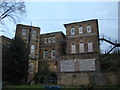
- Clicking on the map will re-center to the selected point.
- The higher the marker number, the further away the image location is from the centre of the postcode.
Image Listing (189 Images Found)
Images are licensed for reuse under creativecommons.org/licenses/by-sa/2.0
Image
Details
Distance
1
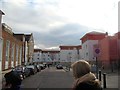
View down Merchant Street from Mile End Road
Looking south-southeast. The modern flats here contrast quite significantly with the architecture of Bow Road Methodist Church on the left.
Image: © Robert Lamb
Taken: 1 Dec 2012
0.01 miles
2
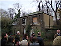
The former mortuary
Now housing the electricity generators of the site. Behind it is the pathway which passes through Tower Hamlets Cemetery Park. Looking south-southeast. If you're wondering how I got access into the site (the site has been closed to the public since 2005), I have two friends from university who are working on a project to convert the hospital site into a Community Land Trust, passed by Boris Johnson last year. Read more about it here: http://www.jtp.co.uk/community-planning-projects/st-clements/
Image: © Robert Lamb
Taken: 1 Dec 2012
0.01 miles
3
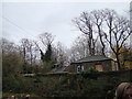
View of the former mortuary from the garden
Looking south-southeast.
Image: © Robert Lamb
Taken: 1 Dec 2012
0.01 miles
4
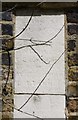
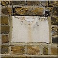
Old Boundary Marker by Hamlets Way, Stepney
Parish Boundary Marker by the UC road, in parish of Stepney (Tower Hamlets District), Hamlets Way E3, path North of, and overlooking cemetery, next to gateway, top stone.
Tower Hamlets Cemetery Boundary Wall and gate piers are Grade II Listed.
List Entry Number: 1065056
https://historicengland.org.uk/listing/the-list/list-entry/1065056
Surveyed
Milestone Society National ID: MX_BSL01pb
Image: © Milestone Society
Taken: Unknown
0.03 miles
5
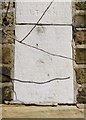
Old Boundary Marker by Hamlets Way, Stepney
Parish Boundary Marker by the UC road, in parish of Stepney (Tower Hamlets District), Hamlets Way E3, path North of, and overlooking cemetery, next to gateway, third from top.
Tower Hamlets Cemetery Boundary Wall and gate piers are Grade II Listed.
List Entry Number: 1065056 https://historicengland.org.uk/listing/the-list/list-entry/1065056
Surveyed
Milestone Society National ID: MX_BSL03pb
Image: © Milestone Society
Taken: Unknown
0.03 miles
6
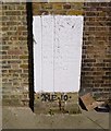
Old Boundary Marker by Hamlets Way, Stepney parish
Parish Boundary Marker by the UC road, in parish of Stepney (Tower Hamlets District), Hamlets Way E3, by path North of, and overlooking cemetery, next to gateway second from top.
Tower Hamlets Cemetery Boundary Wall and gate piers are Grade II Listed.
List Entry Number: 1065056
https://historicengland.org.uk/listing/the-list/list-entry/1065056
Surveyed
Milestone Society National ID: MX_BSL02pb
Image: © Milestone Society
Taken: Unknown
0.03 miles
7
Old Boundary Marker by Hamlets Way, Stepney
Parish Boundary Marker by the UC road, in parish of Stepney (Tower Hamlets District), Hamlets Way E3, path North of, and overlooking cemetery, next to gateway, bottom stone.
Tower Hamlets Cemetery Boundary Wall and gate piers are Grade II listed.
List Entry Number: 1065056 https://historicengland.org.uk/listing/the-list/list-entry/1065056
Surveyed
Milestone Society National ID: MX_BSL04pb
Image: © Milestone Society
Taken: Unknown
0.03 miles
8
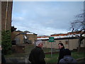
View of modern flats on British Street from the St Clement's Hospital site #2
Looking north-northeast. The flats certainly do add a significant contrast to the run down, morbid nature of the hospital buildings. If you're wondering how I got access into the site (the site has been closed to the public since 2005), I have two friends from university who are working on a project to convert the hospital site into a Community Land Trust, passed by Boris Johnson last year. Read more about it here: http://www.jtp.co.uk/community-planning-projects/st-clements/
Image: © Robert Lamb
Taken: 1 Dec 2012
0.05 miles
9
View of the rear of the main building of St Clement's Hospital
Looking south-southwest from the garden. If you're wondering how I got access into the site (the site has been closed to the public since 2005), I have two friends from university who are working on a project to convert the hospital site into a Community Land Trust, passed by Boris Johnson last year. Read more about it here: http://www.jtp.co.uk/community-planning-projects/st-clements/
Image: © Robert Lamb
Taken: 1 Dec 2012
0.05 miles
10
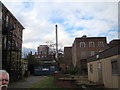
View of the hospital chimney from the St Clement's Hospital drive
Looking south-southwest. If you're wondering how I got access into the site (the site has been closed to the public since 2005), I have two friends from university who are working on a project to convert the hospital site into a Community Land Trust, passed by Boris Johnson last year. Read more about it here: http://www.jtp.co.uk/community-planning-projects/st-clements/
Image: © Robert Lamb
Taken: 1 Dec 2012
0.05 miles